You are here: Home > Network List > TA - USArray Transportable Network (new EarthScope stations) Stations List
> Station A20A Cobblestone Ranch, Loring, MT, USA > Earthquake Result Viewer
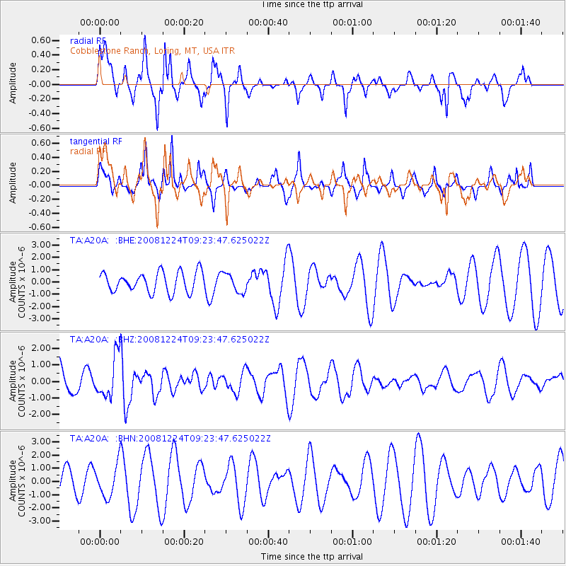
A20A Cobblestone Ranch, Loring, MT, USA - Earthquake Result Viewer
*The percent match for this event was below the threshold and hence no stack was calculated.
| Earthquake location: |
Tonga Islands Region |
| Earthquake latitude/longitude: |
-17.3/-171.9 |
| Earthquake time(UTC): |
2008/12/24 (359) 09:11:34 GMT |
| Earthquake Depth: |
9.0 km |
| Earthquake Magnitude: |
5.9 MB, 5.6 MS, 6.0 MW, 6.0 MW |
| Earthquake Catalog/Contributor: |
WHDF/NEIC |
|
| Network: |
TA USArray Transportable Network (new EarthScope stations) |
| Station: |
A20A Cobblestone Ranch, Loring, MT, USA |
| Lat/Lon: |
48.88 N/107.93 W |
| Elevation: |
868 m |
|
| Distance: |
86.9 deg |
| Az: |
36.451 deg |
| Baz: |
239.3 deg |
| Ray Param: |
$rayparam |
*The percent match for this event was below the threshold and hence was not used in the summary stack. |
|
| Radial Match: |
65.48127 % |
| Radial Bump: |
400 |
| Transverse Match: |
78.348816 % |
| Transverse Bump: |
333 |
| SOD ConfigId: |
2658 |
| Insert Time: |
2010-03-07 00:19:58.347 +0000 |
| GWidth: |
2.5 |
| Max Bumps: |
400 |
| Tol: |
0.001 |
|
Signal To Noise
| Channel | StoN | STA | LTA |
| TA:A20A: :BHZ:20081224T09:23:47.625022Z | 1.7521116 | 1.295921E-6 | 7.396339E-7 |
| TA:A20A: :BHN:20081224T09:23:47.625022Z | 1.3125306 | 1.2552614E-6 | 9.563673E-7 |
| TA:A20A: :BHE:20081224T09:23:47.625022Z | 0.9535823 | 7.721428E-7 | 8.097286E-7 |
| Arrivals |
| Ps | |
| PpPs | |
| PsPs/PpSs | |


