You are here: Home > Network List > TA - USArray Transportable Network (new EarthScope stations) Stations List
> Station A20A Cobblestone Ranch, Loring, MT, USA > Earthquake Result Viewer
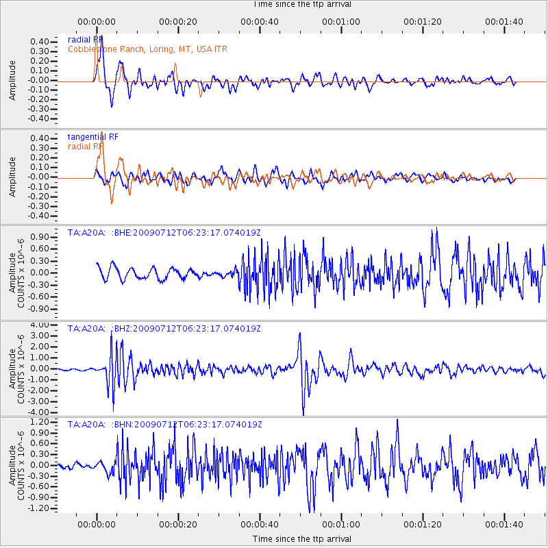
A20A Cobblestone Ranch, Loring, MT, USA - Earthquake Result Viewer
*The percent match for this event was below the threshold and hence no stack was calculated.
| Earthquake location: |
Southern Peru |
| Earthquake latitude/longitude: |
-15.0/-70.4 |
| Earthquake time(UTC): |
2009/07/12 (193) 06:12:47 GMT |
| Earthquake Depth: |
199 km |
| Earthquake Magnitude: |
5.7 MB, 6.1 MW, 6.1 MW |
| Earthquake Catalog/Contributor: |
WHDF/NEIC |
|
| Network: |
TA USArray Transportable Network (new EarthScope stations) |
| Station: |
A20A Cobblestone Ranch, Loring, MT, USA |
| Lat/Lon: |
48.88 N/107.93 W |
| Elevation: |
868 m |
|
| Distance: |
71.8 deg |
| Az: |
334.985 deg |
| Baz: |
141.765 deg |
| Ray Param: |
$rayparam |
*The percent match for this event was below the threshold and hence was not used in the summary stack. |
|
| Radial Match: |
87.37971 % |
| Radial Bump: |
400 |
| Transverse Match: |
81.40926 % |
| Transverse Bump: |
400 |
| SOD ConfigId: |
2648 |
| Insert Time: |
2010-03-07 00:20:06.203 +0000 |
| GWidth: |
2.5 |
| Max Bumps: |
400 |
| Tol: |
0.001 |
|
Signal To Noise
| Channel | StoN | STA | LTA |
| TA:A20A: :BHZ:20090712T06:23:17.074019Z | 27.643559 | 1.3410835E-6 | 4.8513414E-8 |
| TA:A20A: :BHN:20090712T06:23:17.074019Z | 0.9496088 | 1.5366253E-7 | 1.6181667E-7 |
| TA:A20A: :BHE:20090712T06:23:17.074019Z | 0.5442592 | 7.4050384E-8 | 1.3605721E-7 |
| Arrivals |
| Ps | |
| PpPs | |
| PsPs/PpSs | |


