You are here: Home > Network List > NE - New England Seismic Network Stations List
> Station BCX Chestnut Hill, MA, USA > Earthquake Result Viewer
BCX Chestnut Hill, MA, USA - Earthquake Result Viewer
| Earthquake location: |
Off Coast Of Central America |
| Earthquake latitude/longitude: |
12.0/-88.8 |
| Earthquake time(UTC): |
2016/11/24 (329) 18:43:48 GMT |
| Earthquake Depth: |
10 km |
| Earthquake Magnitude: |
7.0 MWW, 6.7 MWB, 7.2 MI |
| Earthquake Catalog/Contributor: |
NEIC PDE/NEIC COMCAT |
|
| Network: |
NE New England Seismic Network |
| Station: |
BCX Chestnut Hill, MA, USA |
| Lat/Lon: |
42.33 N/71.17 W |
| Elevation: |
60 m |
|
| Distance: |
34.0 deg |
| Az: |
23.758 deg |
| Baz: |
212.121 deg |
| Ray Param: |
0.07797095 |
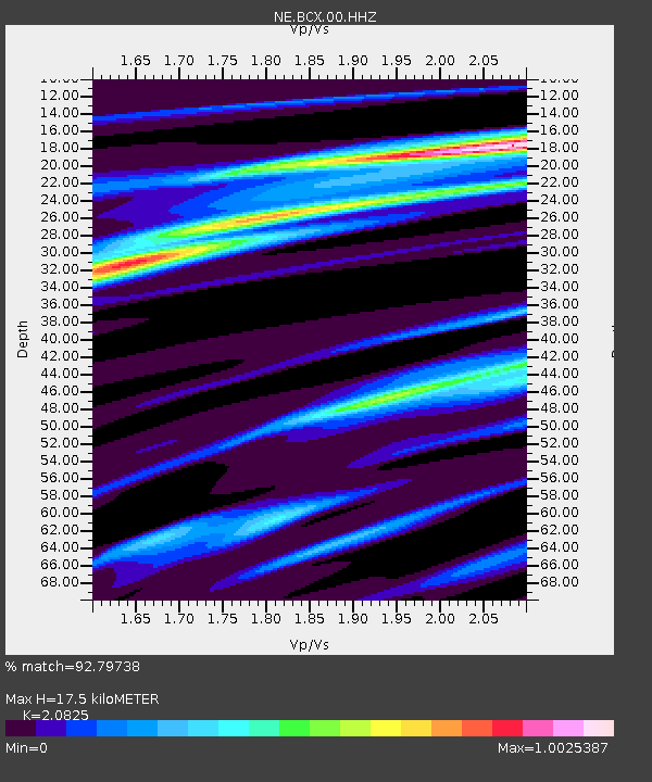
| Estimated Moho Depth: |
17.5 km |
| Estimated Crust Vp/Vs: |
2.08 |
| Assumed Crust Vp: |
6.419 km/s |
| Estimated Crust Vs: |
3.082 km/s |
| Estimated Crust Poisson's Ratio: |
0.35 |
|
| Radial Match: |
92.79738 % |
| Radial Bump: |
252 |
| Transverse Match: |
62.163853 % |
| Transverse Bump: |
400 |
| SOD ConfigId: |
1858631 |
| Insert Time: |
2016-12-08 18:46:56.809 +0000 |
| GWidth: |
2.5 |
| Max Bumps: |
400 |
| Tol: |
0.001 |
|

Signal To Noise
| Channel | StoN | STA | LTA |
| NE:BCX:00:HHZ:20161124T18:50:01.414015Z | 11.319105 | 6.672358E-6 | 5.894775E-7 |
| NE:BCX:00:HH1:20161124T18:50:01.414015Z | 7.533515 | 3.4910493E-6 | 4.6340244E-7 |
| NE:BCX:00:HH2:20161124T18:50:01.414015Z | 4.885283 | 2.1428461E-6 | 4.3863292E-7 |
| Arrivals |
| Ps | 3.2 SECOND |
| PpPs | 7.9 SECOND |
| PsPs/PpSs | 11 SECOND |


