You are here: Home > Network List > NE - New England Seismic Network Stations List
> Station FFD Franklin Falls Dam, NH, USA > Earthquake Result Viewer
FFD Franklin Falls Dam, NH, USA - Earthquake Result Viewer
| Earthquake location: |
Off Coast Of Central America |
| Earthquake latitude/longitude: |
12.0/-88.8 |
| Earthquake time(UTC): |
2016/11/24 (329) 18:43:48 GMT |
| Earthquake Depth: |
10 km |
| Earthquake Magnitude: |
7.0 MWW, 6.7 MWB, 7.2 MI |
| Earthquake Catalog/Contributor: |
NEIC PDE/NEIC COMCAT |
|
| Network: |
NE New England Seismic Network |
| Station: |
FFD Franklin Falls Dam, NH, USA |
| Lat/Lon: |
43.47 N/71.65 W |
| Elevation: |
131 m |
|
| Distance: |
34.7 deg |
| Az: |
22.176 deg |
| Baz: |
210.487 deg |
| Ray Param: |
0.0775872 |
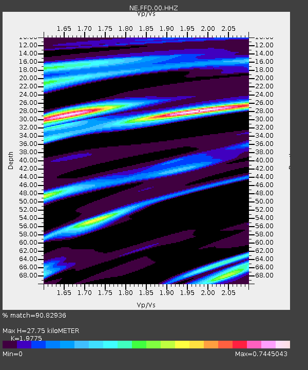
| Estimated Moho Depth: |
27.75 km |
| Estimated Crust Vp/Vs: |
1.98 |
| Assumed Crust Vp: |
6.419 km/s |
| Estimated Crust Vs: |
3.246 km/s |
| Estimated Crust Poisson's Ratio: |
0.33 |
|
| Radial Match: |
90.82936 % |
| Radial Bump: |
332 |
| Transverse Match: |
54.626743 % |
| Transverse Bump: |
400 |
| SOD ConfigId: |
1858631 |
| Insert Time: |
2016-12-08 18:47:02.144 +0000 |
| GWidth: |
2.5 |
| Max Bumps: |
400 |
| Tol: |
0.001 |
|

Signal To Noise
| Channel | StoN | STA | LTA |
| NE:FFD:00:HHZ:20161124T18:50:08.189009Z | 14.175034 | 6.7213873E-6 | 4.741708E-7 |
| NE:FFD:00:HH1:20161124T18:50:08.189009Z | 5.68912 | 4.062922E-6 | 7.1415656E-7 |
| NE:FFD:00:HH2:20161124T18:50:08.189009Z | 5.194512 | 2.2633917E-6 | 4.3572751E-7 |
| Arrivals |
| Ps | 4.5 SECOND |
| PpPs | 12 SECOND |
| PsPs/PpSs | 17 SECOND |


