You are here: Home > Network List > NE - New England Seismic Network Stations List
> Station QUA2 Belchertown, MA, USA > Earthquake Result Viewer
QUA2 Belchertown, MA, USA - Earthquake Result Viewer
| Earthquake location: |
Off Coast Of Central America |
| Earthquake latitude/longitude: |
12.0/-88.8 |
| Earthquake time(UTC): |
2016/11/24 (329) 18:43:48 GMT |
| Earthquake Depth: |
10 km |
| Earthquake Magnitude: |
7.0 MWW, 6.7 MWB, 7.2 MI |
| Earthquake Catalog/Contributor: |
NEIC PDE/NEIC COMCAT |
|
| Network: |
NE New England Seismic Network |
| Station: |
QUA2 Belchertown, MA, USA |
| Lat/Lon: |
42.28 N/72.35 W |
| Elevation: |
168 m |
|
| Distance: |
33.4 deg |
| Az: |
22.459 deg |
| Baz: |
210.248 deg |
| Ray Param: |
0.078201964 |
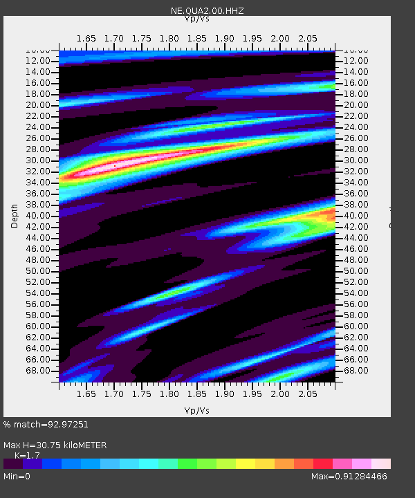
| Estimated Moho Depth: |
30.75 km |
| Estimated Crust Vp/Vs: |
1.70 |
| Assumed Crust Vp: |
6.419 km/s |
| Estimated Crust Vs: |
3.776 km/s |
| Estimated Crust Poisson's Ratio: |
0.24 |
|
| Radial Match: |
92.97251 % |
| Radial Bump: |
305 |
| Transverse Match: |
49.072372 % |
| Transverse Bump: |
400 |
| SOD ConfigId: |
1858631 |
| Insert Time: |
2016-12-08 18:47:06.127 +0000 |
| GWidth: |
2.5 |
| Max Bumps: |
400 |
| Tol: |
0.001 |
|

Signal To Noise
| Channel | StoN | STA | LTA |
| NE:QUA2:00:HHZ:20161124T18:49:57.060011Z | 10.029486 | 6.55863E-6 | 6.539348E-7 |
| NE:QUA2:00:HH1:20161124T18:49:57.060011Z | 11.994427 | 3.708649E-6 | 3.091977E-7 |
| NE:QUA2:00:HH2:20161124T18:49:57.060011Z | 3.9094536 | 2.5796446E-6 | 6.5984784E-7 |
| Arrivals |
| Ps | 3.6 SECOND |
| PpPs | 12 SECOND |
| PsPs/PpSs | 16 SECOND |


