You are here: Home > Network List > TS - TERRAscope (Southern California Seismic Network) Stations List
> Station GSC Goldston, California, USA > Earthquake Result Viewer
GSC Goldston, California, USA - Earthquake Result Viewer
| Earthquake location: |
Near Coast Of Central Chile |
| Earthquake latitude/longitude: |
-30.5/-71.9 |
| Earthquake time(UTC): |
1997/07/25 (206) 06:47:02 GMT |
| Earthquake Depth: |
33 km |
| Earthquake Magnitude: |
5.6 MB, 5.5 MS, 6.3 UNKNOWN |
| Earthquake Catalog/Contributor: |
WHDF/NEIC |
|
| Network: |
TS TERRAscope (Southern California Seismic Network) |
| Station: |
GSC Goldston, California, USA |
| Lat/Lon: |
35.30 N/116.81 W |
| Elevation: |
990 m |
|
| Distance: |
77.9 deg |
| Az: |
323.804 deg |
| Baz: |
141.434 deg |
| Ray Param: |
0.04997817 |
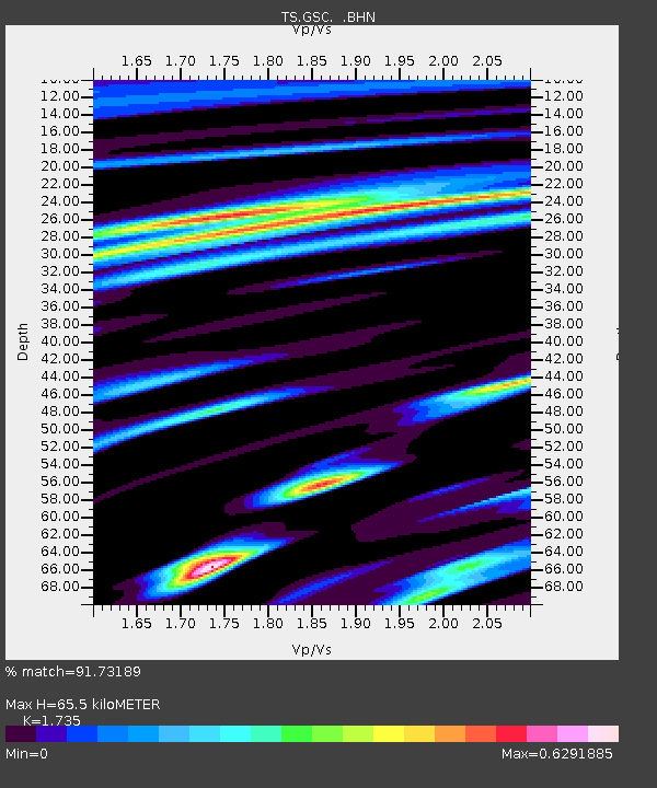
| Estimated Moho Depth: |
65.5 km |
| Estimated Crust Vp/Vs: |
1.74 |
| Assumed Crust Vp: |
6.276 km/s |
| Estimated Crust Vs: |
3.617 km/s |
| Estimated Crust Poisson's Ratio: |
0.25 |
|
| Radial Match: |
91.73189 % |
| Radial Bump: |
400 |
| Transverse Match: |
74.83833 % |
| Transverse Bump: |
400 |
| SOD ConfigId: |
6273 |
| Insert Time: |
2010-02-26 14:18:08.181 +0000 |
| GWidth: |
2.5 |
| Max Bumps: |
400 |
| Tol: |
0.001 |
|

Signal To Noise
| Channel | StoN | STA | LTA |
| TS:GSC: :BHN:19970725T06:58:25.948022Z | 0.8255488 | 6.4213566E-8 | 7.7782886E-8 |
| TS:GSC: :BHE:19970725T06:58:25.948022Z | 0.7877103 | 6.267182E-8 | 7.956202E-8 |
| TS:GSC: :BHZ:19970725T06:58:25.948022Z | 2.440253 | 1.9387639E-7 | 7.94493E-8 |
| Arrivals |
| Ps | 7.9 SECOND |
| PpPs | 28 SECOND |
| PsPs/PpSs | 36 SECOND |


