You are here: Home > Network List > NE - New England Seismic Network Stations List
> Station WES Weston Observatory, Weston, MA, USA > Earthquake Result Viewer
WES Weston Observatory, Weston, MA, USA - Earthquake Result Viewer
| Earthquake location: |
Off Coast Of Central America |
| Earthquake latitude/longitude: |
12.0/-88.8 |
| Earthquake time(UTC): |
2016/11/24 (329) 18:43:48 GMT |
| Earthquake Depth: |
10 km |
| Earthquake Magnitude: |
7.0 MWW, 6.7 MWB, 7.2 MI |
| Earthquake Catalog/Contributor: |
NEIC PDE/NEIC COMCAT |
|
| Network: |
NE New England Seismic Network |
| Station: |
WES Weston Observatory, Weston, MA, USA |
| Lat/Lon: |
42.38 N/71.32 W |
| Elevation: |
60 m |
|
| Distance: |
33.9 deg |
| Az: |
23.541 deg |
| Baz: |
211.839 deg |
| Ray Param: |
0.07797886 |
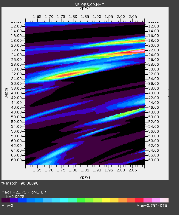
| Estimated Moho Depth: |
21.75 km |
| Estimated Crust Vp/Vs: |
2.10 |
| Assumed Crust Vp: |
6.419 km/s |
| Estimated Crust Vs: |
3.06 km/s |
| Estimated Crust Poisson's Ratio: |
0.35 |
|
| Radial Match: |
90.86098 % |
| Radial Bump: |
177 |
| Transverse Match: |
60.74539 % |
| Transverse Bump: |
400 |
| SOD ConfigId: |
1858631 |
| Insert Time: |
2016-12-08 18:47:10.268 +0000 |
| GWidth: |
2.5 |
| Max Bumps: |
400 |
| Tol: |
0.001 |
|

Signal To Noise
| Channel | StoN | STA | LTA |
| NE:WES:00:HHZ:20161124T18:50:01.26399Z | 13.571396 | 6.8351123E-6 | 5.036411E-7 |
| NE:WES:00:HH1:20161124T18:50:01.26399Z | 7.9517093 | 3.9528286E-6 | 4.971043E-7 |
| NE:WES:00:HH2:20161124T18:50:01.26399Z | 8.169659 | 2.7490698E-6 | 3.3649752E-7 |
| Arrivals |
| Ps | 4.0 SECOND |
| PpPs | 9.8 SECOND |
| PsPs/PpSs | 14 SECOND |


