You are here: Home > Network List > TA - USArray Transportable Network (new EarthScope stations) Stations List
> Station A20A Cobblestone Ranch, Loring, MT, USA > Earthquake Result Viewer
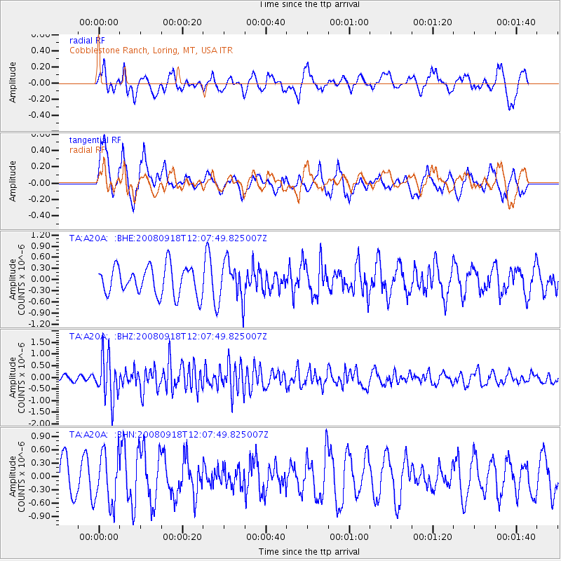
A20A Cobblestone Ranch, Loring, MT, USA - Earthquake Result Viewer
*The percent match for this event was below the threshold and hence no stack was calculated.
| Earthquake location: |
Near East Coast Of Kamchatka |
| Earthquake latitude/longitude: |
51.9/158.4 |
| Earthquake time(UTC): |
2008/09/18 (262) 11:58:50 GMT |
| Earthquake Depth: |
67 km |
| Earthquake Magnitude: |
5.7 MB, 5.9 MW, 5.8 MW |
| Earthquake Catalog/Contributor: |
WHDF/NEIC |
|
| Network: |
TA USArray Transportable Network (new EarthScope stations) |
| Station: |
A20A Cobblestone Ranch, Loring, MT, USA |
| Lat/Lon: |
48.88 N/107.93 W |
| Elevation: |
868 m |
|
| Distance: |
55.7 deg |
| Az: |
52.883 deg |
| Baz: |
311.574 deg |
| Ray Param: |
$rayparam |
*The percent match for this event was below the threshold and hence was not used in the summary stack. |
|
| Radial Match: |
48.46637 % |
| Radial Bump: |
396 |
| Transverse Match: |
59.918995 % |
| Transverse Bump: |
348 |
| SOD ConfigId: |
2560 |
| Insert Time: |
2010-03-07 00:20:32.086 +0000 |
| GWidth: |
2.5 |
| Max Bumps: |
400 |
| Tol: |
0.001 |
|
Signal To Noise
| Channel | StoN | STA | LTA |
| TA:A20A: :BHZ:20080918T12:07:49.825007Z | 7.078196 | 9.407268E-7 | 1.3290489E-7 |
| TA:A20A: :BHN:20080918T12:07:49.825007Z | 1.1576781 | 5.731669E-7 | 4.951004E-7 |
| TA:A20A: :BHE:20080918T12:07:49.825007Z | 1.329567 | 5.080539E-7 | 3.8211985E-7 |
| Arrivals |
| Ps | |
| PpPs | |
| PsPs/PpSs | |


