You are here: Home > Network List > TA - USArray Transportable Network (new EarthScope stations) Stations List
> Station C16A Fuhringer Ranch, Dutton, MT, USA > Earthquake Result Viewer
C16A Fuhringer Ranch, Dutton, MT, USA - Earthquake Result Viewer
| Earthquake location: |
Sichuan, China |
| Earthquake latitude/longitude: |
32.8/105.5 |
| Earthquake time(UTC): |
2008/08/05 (218) 09:49:17 GMT |
| Earthquake Depth: |
6.0 km |
| Earthquake Magnitude: |
5.9 MB, 6.0 MS, 6.0 MW, 5.9 MW |
| Earthquake Catalog/Contributor: |
WHDF/NEIC |
|
| Network: |
TA USArray Transportable Network (new EarthScope stations) |
| Station: |
C16A Fuhringer Ranch, Dutton, MT, USA |
| Lat/Lon: |
47.80 N/111.75 W |
| Elevation: |
1240 m |
|
| Distance: |
93.1 deg |
| Az: |
24.116 deg |
| Baz: |
329.291 deg |
| Ray Param: |
0.04132407 |
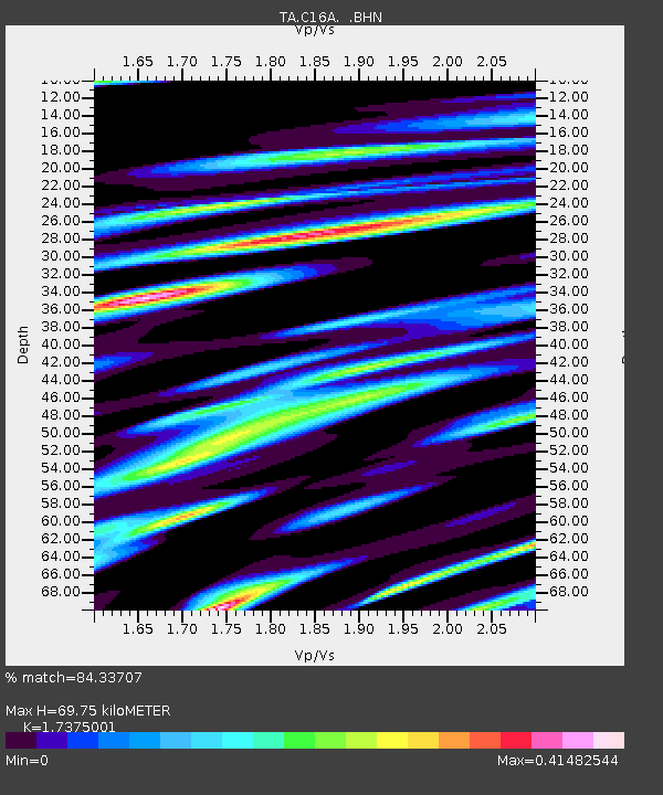
| Estimated Moho Depth: |
69.75 km |
| Estimated Crust Vp/Vs: |
1.74 |
| Assumed Crust Vp: |
6.306 km/s |
| Estimated Crust Vs: |
3.629 km/s |
| Estimated Crust Poisson's Ratio: |
0.25 |
|
| Radial Match: |
84.33707 % |
| Radial Bump: |
400 |
| Transverse Match: |
78.03638 % |
| Transverse Bump: |
400 |
| SOD ConfigId: |
2504 |
| Insert Time: |
2010-03-07 00:21:04.195 +0000 |
| GWidth: |
2.5 |
| Max Bumps: |
400 |
| Tol: |
0.001 |
|
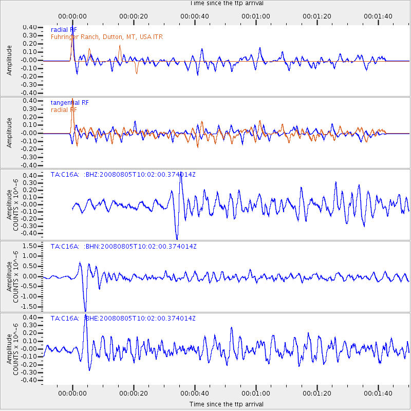
Signal To Noise
| Channel | StoN | STA | LTA |
| TA:C16A: :BHN:20080805T10:02:00.374014Z | 14.851267 | 6.571409E-7 | 4.424814E-8 |
| TA:C16A: :BHE:20080805T10:02:00.374014Z | 4.9948454 | 1.7057218E-7 | 3.414964E-8 |
| TA:C16A: :BHZ:20080805T10:02:00.374014Z | 4.561645 | 1.8942713E-7 | 4.1526057E-8 |
| Arrivals |
| Ps | 8.3 SECOND |
| PpPs | 30 SECOND |
| PsPs/PpSs | 38 SECOND |


