You are here: Home > Network List > TA - USArray Transportable Network (new EarthScope stations) Stations List
> Station C16A Fuhringer Ranch, Dutton, MT, USA > Earthquake Result Viewer
C16A Fuhringer Ranch, Dutton, MT, USA - Earthquake Result Viewer

| Earthquake location: |
Virgin Islands |
| Earthquake latitude/longitude: |
19.2/-64.8 |
| Earthquake time(UTC): |
2008/10/11 (285) 10:40:14 GMT |
| Earthquake Depth: |
23 km |
| Earthquake Magnitude: |
6.1 MB, 5.9 MS, 6.1 MW, 6.0 MW |
| Earthquake Catalog/Contributor: |
WHDF/NEIC |
|
| Network: |
TA USArray Transportable Network (new EarthScope stations) |
| Station: |
C16A Fuhringer Ranch, Dutton, MT, USA |
| Lat/Lon: |
47.80 N/111.75 W |
| Elevation: |
1240 m |
|
| Distance: |
47.4 deg |
| Az: |
318.056 deg |
| Baz: |
110.416 deg |
| Ray Param: |
0.06994947 |
| Estimated Moho Depth: |
27.5 km |
| Estimated Crust Vp/Vs: |
1.69 |
| Assumed Crust Vp: |
6.306 km/s |
| Estimated Crust Vs: |
3.737 km/s |
| Estimated Crust Poisson's Ratio: |
0.23 |
|
| Radial Match: |
82.63573 % |
| Radial Bump: |
341 |
| Transverse Match: |
67.75065 % |
| Transverse Bump: |
400 |
| SOD ConfigId: |
2556 |
| Insert Time: |
2010-03-07 00:21:14.983 +0000 |
| GWidth: |
2.5 |
| Max Bumps: |
400 |
| Tol: |
0.001 |
|
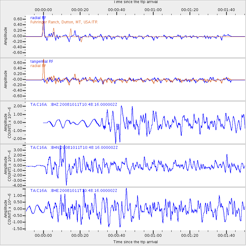
Signal To Noise
| Channel | StoN | STA | LTA |
| TA:C16A: :BHN:20081011T10:48:16.000002Z | 5.113573 | 9.786859E-7 | 1.9138983E-7 |
| TA:C16A: :BHE:20081011T10:48:16.000002Z | 1.883247 | 3.000116E-7 | 1.593055E-7 |
| TA:C16A: :BHZ:20081011T10:48:16.000002Z | 1.8805745 | 4.978317E-7 | 2.647232E-7 |
| Arrivals |
| Ps | 3.2 SECOND |
| PpPs | 11 SECOND |
| PsPs/PpSs | 14 SECOND |


