You are here: Home > Network List > TA - USArray Transportable Network (new EarthScope stations) Stations List
> Station C16A Fuhringer Ranch, Dutton, MT, USA > Earthquake Result Viewer
C16A Fuhringer Ranch, Dutton, MT, USA - Earthquake Result Viewer
| Earthquake location: |
Central East Pacific Rise |
| Earthquake latitude/longitude: |
-9.0/-108.2 |
| Earthquake time(UTC): |
2008/10/30 (304) 15:15:41 GMT |
| Earthquake Depth: |
10 km |
| Earthquake Magnitude: |
5.5 MB, 5.8 MS, 6.0 MW, 6.0 MW |
| Earthquake Catalog/Contributor: |
WHDF/NEIC |
|
| Network: |
TA USArray Transportable Network (new EarthScope stations) |
| Station: |
C16A Fuhringer Ranch, Dutton, MT, USA |
| Lat/Lon: |
47.80 N/111.75 W |
| Elevation: |
1240 m |
|
| Distance: |
56.7 deg |
| Az: |
357.176 deg |
| Baz: |
175.861 deg |
| Ray Param: |
0.06399984 |
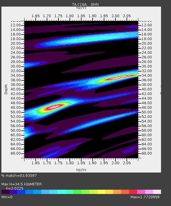
| Estimated Moho Depth: |
34.5 km |
| Estimated Crust Vp/Vs: |
2.02 |
| Assumed Crust Vp: |
6.306 km/s |
| Estimated Crust Vs: |
3.118 km/s |
| Estimated Crust Poisson's Ratio: |
0.34 |
|
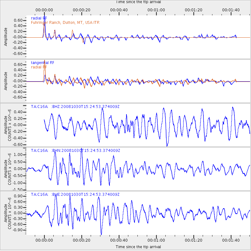
| Radial Match: |
83.93597 % |
| Radial Bump: |
289 |
| Transverse Match: |
59.42121 % |
| Transverse Bump: |
354 |
| SOD ConfigId: |
2560 |
| Insert Time: |
2010-03-07 00:21:30.410 +0000 |
| GWidth: |
2.5 |
| Max Bumps: |
400 |
| Tol: |
0.001 |
|
Signal To Noise
| Channel | StoN | STA | LTA |
| TA:C16A: :BHN:20081030T15:24:53.374009Z | 3.1945894 | 3.9342424E-7 | 1.231533E-7 |
| TA:C16A: :BHE:20081030T15:24:53.374009Z | 3.209086 | 3.4238684E-7 | 1.0669295E-7 |
| TA:C16A: :BHZ:20081030T15:24:53.374009Z | 2.0209384 | 3.4044336E-7 | 1.6845807E-7 |
| Arrivals |
| Ps | 5.8 SECOND |
| PpPs | 16 SECOND |
| PsPs/PpSs | 22 SECOND |


