You are here: Home > Network List > TA - USArray Transportable Network (new EarthScope stations) Stations List
> Station C16A Fuhringer Ranch, Dutton, MT, USA > Earthquake Result Viewer
C16A Fuhringer Ranch, Dutton, MT, USA - Earthquake Result Viewer
| Earthquake location: |
Santa Cruz Islands Region |
| Earthquake latitude/longitude: |
-11.0/164.5 |
| Earthquake time(UTC): |
2008/07/19 (201) 09:27:01 GMT |
| Earthquake Depth: |
11 km |
| Earthquake Magnitude: |
6.1 MB, 6.4 MS, 6.6 MW, 6.6 MW |
| Earthquake Catalog/Contributor: |
WHDF/NEIC |
|
| Network: |
TA USArray Transportable Network (new EarthScope stations) |
| Station: |
C16A Fuhringer Ranch, Dutton, MT, USA |
| Lat/Lon: |
47.80 N/111.75 W |
| Elevation: |
1240 m |
|
| Distance: |
93.9 deg |
| Az: |
42.204 deg |
| Baz: |
258.02 deg |
| Ray Param: |
0.04115966 |
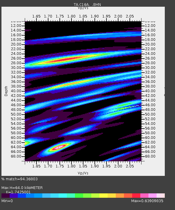
| Estimated Moho Depth: |
64.0 km |
| Estimated Crust Vp/Vs: |
1.74 |
| Assumed Crust Vp: |
6.306 km/s |
| Estimated Crust Vs: |
3.619 km/s |
| Estimated Crust Poisson's Ratio: |
0.25 |
|
| Radial Match: |
94.36803 % |
| Radial Bump: |
400 |
| Transverse Match: |
88.37165 % |
| Transverse Bump: |
400 |
| SOD ConfigId: |
2658 |
| Insert Time: |
2010-03-07 00:21:37.815 +0000 |
| GWidth: |
2.5 |
| Max Bumps: |
400 |
| Tol: |
0.001 |
|
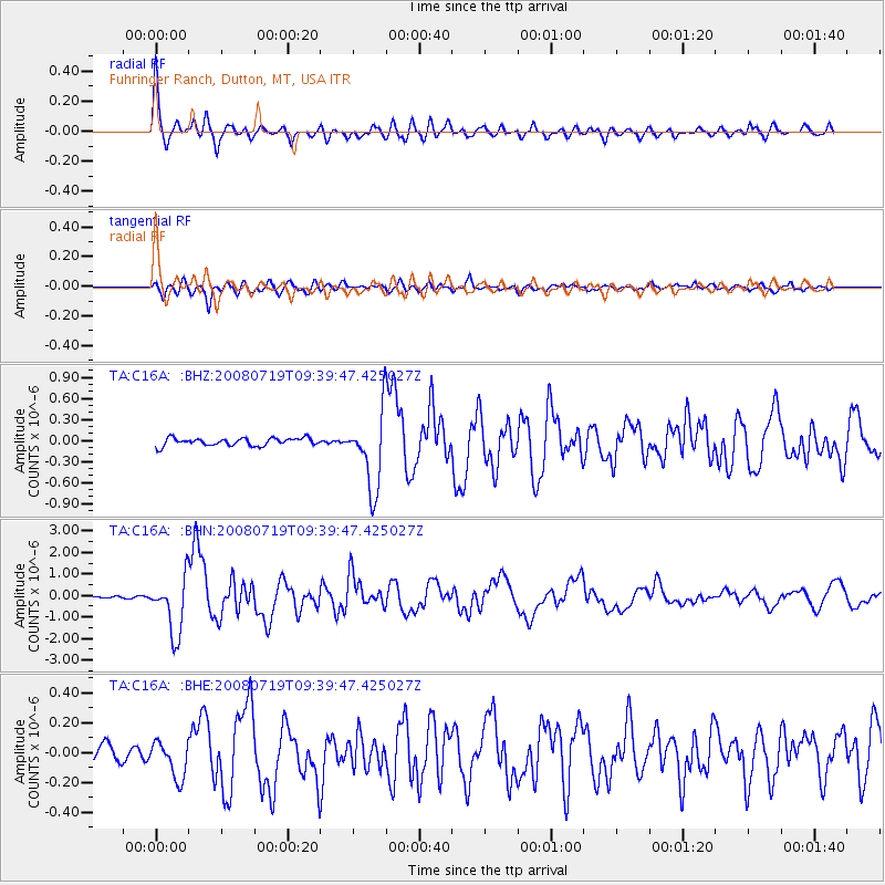
Signal To Noise
| Channel | StoN | STA | LTA |
| TA:C16A: :BHN:20080719T09:39:47.425027Z | 31.974524 | 1.3136104E-6 | 4.108303E-8 |
| TA:C16A: :BHE:20080719T09:39:47.425027Z | 2.8997064 | 1.276491E-7 | 4.402139E-8 |
| TA:C16A: :BHZ:20080719T09:39:47.425027Z | 10.092971 | 5.4398026E-7 | 5.389694E-8 |
| Arrivals |
| Ps | 7.7 SECOND |
| PpPs | 27 SECOND |
| PsPs/PpSs | 35 SECOND |


