You are here: Home > Network List > TA - USArray Transportable Network (new EarthScope stations) Stations List
> Station B18K Kokolik River, AK, USA > Earthquake Result Viewer
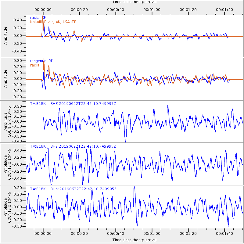
B18K Kokolik River, AK, USA - Earthquake Result Viewer
*The percent match for this event was below the threshold and hence no stack was calculated.
| Earthquake location: |
Near Coast Of Chiapas, Mexico |
| Earthquake latitude/longitude: |
14.5/-92.8 |
| Earthquake time(UTC): |
2019/06/22 (173) 22:31:38 GMT |
| Earthquake Depth: |
38 km |
| Earthquake Magnitude: |
5.6 Mww |
| Earthquake Catalog/Contributor: |
NEIC PDE/us |
|
| Network: |
TA USArray Transportable Network (new EarthScope stations) |
| Station: |
B18K Kokolik River, AK, USA |
| Lat/Lon: |
69.36 N/161.80 W |
| Elevation: |
222 m |
|
| Distance: |
69.2 deg |
| Az: |
339.27 deg |
| Baz: |
104.695 deg |
| Ray Param: |
$rayparam |
*The percent match for this event was below the threshold and hence was not used in the summary stack. |
|
| Radial Match: |
72.33799 % |
| Radial Bump: |
400 |
| Transverse Match: |
48.926105 % |
| Transverse Bump: |
400 |
| SOD ConfigId: |
18369291 |
| Insert Time: |
2019-07-06 22:36:47.970 +0000 |
| GWidth: |
2.5 |
| Max Bumps: |
400 |
| Tol: |
0.001 |
|
Signal To Noise
| Channel | StoN | STA | LTA |
| TA:B18K: :BHZ:20190622T22:42:10.749995Z | 2.2457452 | 3.306361E-7 | 1.472278E-7 |
| TA:B18K: :BHN:20190622T22:42:10.749995Z | 1.070744 | 8.732338E-8 | 8.155393E-8 |
| TA:B18K: :BHE:20190622T22:42:10.749995Z | 0.9913227 | 1.1229828E-7 | 1.1328126E-7 |
| Arrivals |
| Ps | |
| PpPs | |
| PsPs/PpSs | |


