You are here: Home > Network List > TA - USArray Transportable Network (new EarthScope stations) Stations List
> Station E20K Nigu River, AK, USA > Earthquake Result Viewer
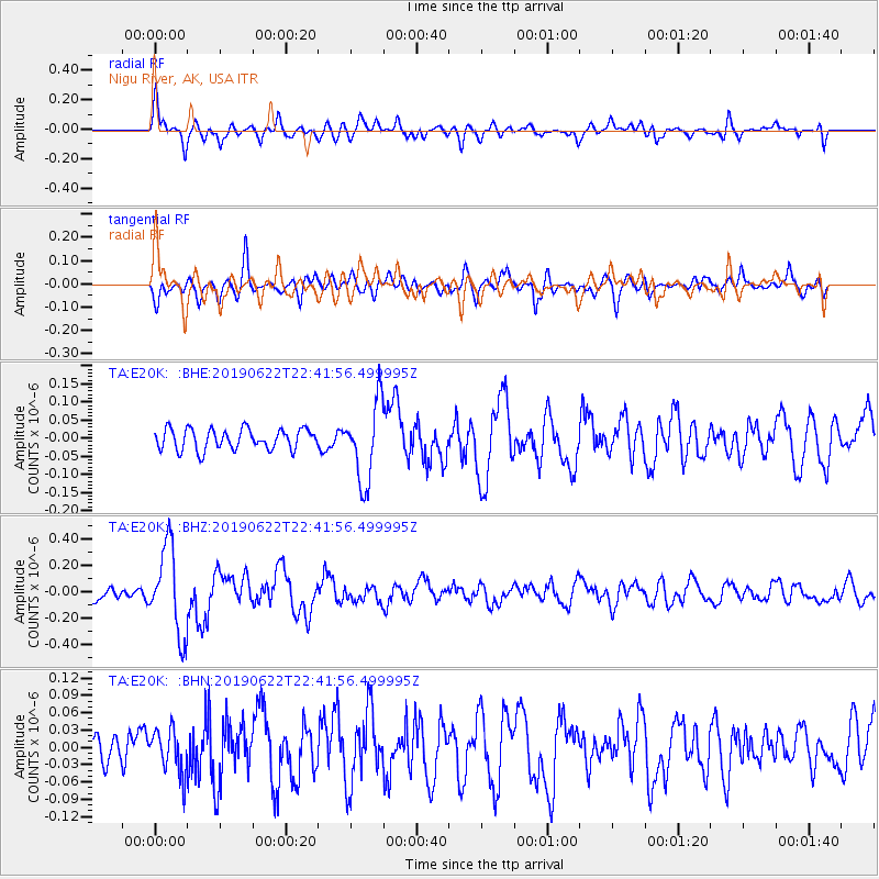
E20K Nigu River, AK, USA - Earthquake Result Viewer
*The percent match for this event was below the threshold and hence no stack was calculated.
| Earthquake location: |
Near Coast Of Chiapas, Mexico |
| Earthquake latitude/longitude: |
14.5/-92.8 |
| Earthquake time(UTC): |
2019/06/22 (173) 22:31:38 GMT |
| Earthquake Depth: |
38 km |
| Earthquake Magnitude: |
5.6 Mww |
| Earthquake Catalog/Contributor: |
NEIC PDE/us |
|
| Network: |
TA USArray Transportable Network (new EarthScope stations) |
| Station: |
E20K Nigu River, AK, USA |
| Lat/Lon: |
68.26 N/156.19 W |
| Elevation: |
866 m |
|
| Distance: |
66.9 deg |
| Az: |
338.777 deg |
| Baz: |
109.741 deg |
| Ray Param: |
$rayparam |
*The percent match for this event was below the threshold and hence was not used in the summary stack. |
|
| Radial Match: |
75.36409 % |
| Radial Bump: |
400 |
| Transverse Match: |
62.215622 % |
| Transverse Bump: |
400 |
| SOD ConfigId: |
18369291 |
| Insert Time: |
2019-07-06 22:37:02.712 +0000 |
| GWidth: |
2.5 |
| Max Bumps: |
400 |
| Tol: |
0.001 |
|
Signal To Noise
| Channel | StoN | STA | LTA |
| TA:E20K: :BHZ:20190622T22:41:56.499995Z | 5.3588514 | 3.2660176E-7 | 6.094623E-8 |
| TA:E20K: :BHN:20190622T22:41:56.499995Z | 1.3944786 | 3.8210633E-8 | 2.7401377E-8 |
| TA:E20K: :BHE:20190622T22:41:56.499995Z | 3.872637 | 1.10167164E-7 | 2.8447582E-8 |
| Arrivals |
| Ps | |
| PpPs | |
| PsPs/PpSs | |


