You are here: Home > Network List > TA - USArray Transportable Network (new EarthScope stations) Stations List
> Station C16A Fuhringer Ranch, Dutton, MT, USA > Earthquake Result Viewer
C16A Fuhringer Ranch, Dutton, MT, USA - Earthquake Result Viewer
| Earthquake location: |
Andreanof Islands, Aleutian Is. |
| Earthquake latitude/longitude: |
51.9/-179.2 |
| Earthquake time(UTC): |
2008/04/16 (107) 05:54:19 GMT |
| Earthquake Depth: |
13 km |
| Earthquake Magnitude: |
6.1 MB, 6.5 MS, 6.6 MW, 6.6 MW |
| Earthquake Catalog/Contributor: |
WHDF/NEIC |
|
| Network: |
TA USArray Transportable Network (new EarthScope stations) |
| Station: |
C16A Fuhringer Ranch, Dutton, MT, USA |
| Lat/Lon: |
47.80 N/111.75 W |
| Elevation: |
1240 m |
|
| Distance: |
42.3 deg |
| Az: |
67.747 deg |
| Baz: |
301.678 deg |
| Ray Param: |
0.07326558 |
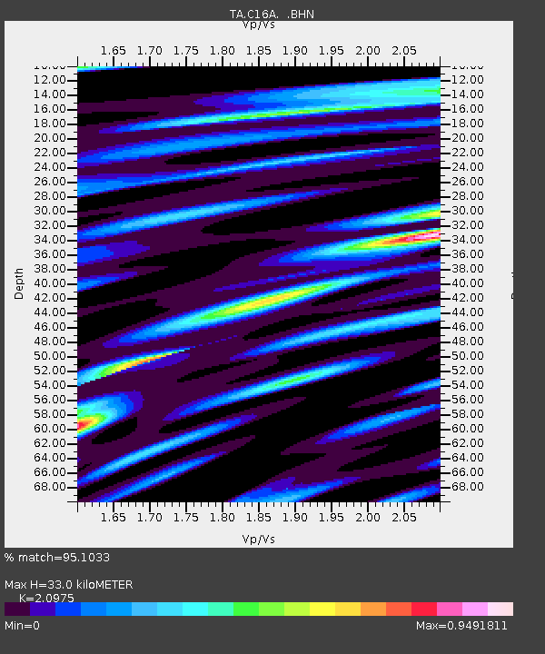
| Estimated Moho Depth: |
33.0 km |
| Estimated Crust Vp/Vs: |
2.10 |
| Assumed Crust Vp: |
6.306 km/s |
| Estimated Crust Vs: |
3.006 km/s |
| Estimated Crust Poisson's Ratio: |
0.35 |
|
| Radial Match: |
95.1033 % |
| Radial Bump: |
361 |
| Transverse Match: |
73.54675 % |
| Transverse Bump: |
400 |
| SOD ConfigId: |
2504 |
| Insert Time: |
2010-03-07 00:22:49.656 +0000 |
| GWidth: |
2.5 |
| Max Bumps: |
400 |
| Tol: |
0.001 |
|
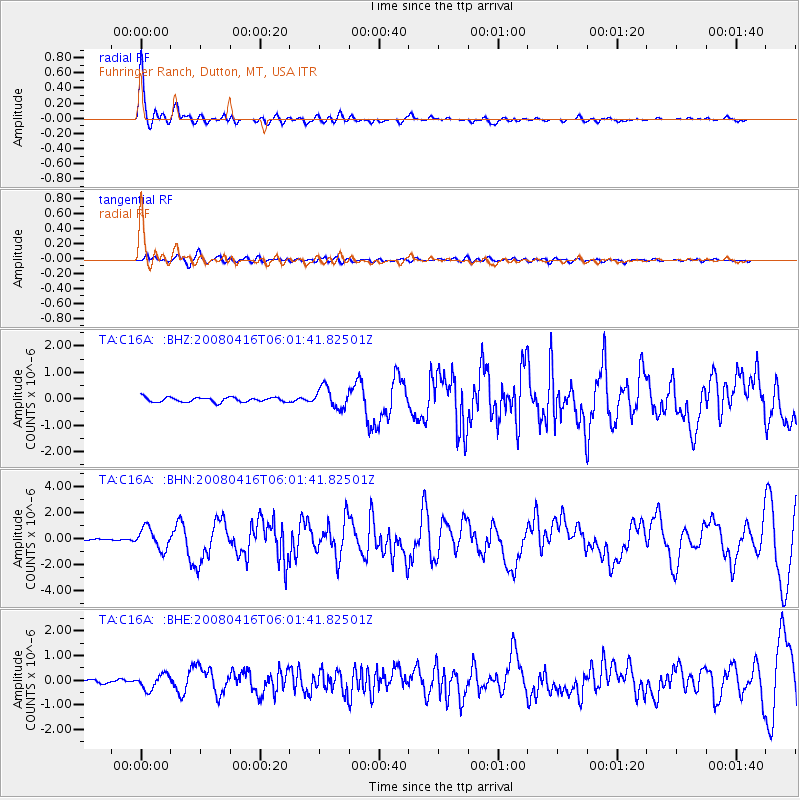
Signal To Noise
| Channel | StoN | STA | LTA |
| TA:C16A: :BHN:20080416T06:01:41.82501Z | 5.436143 | 8.1084994E-7 | 1.4915905E-7 |
| TA:C16A: :BHE:20080416T06:01:41.82501Z | 2.6475387 | 2.9779773E-7 | 1.1248096E-7 |
| TA:C16A: :BHZ:20080416T06:01:41.82501Z | 4.4600267 | 3.906131E-7 | 8.758089E-8 |
| Arrivals |
| Ps | 6.1 SECOND |
| PpPs | 15 SECOND |
| PsPs/PpSs | 21 SECOND |


