You are here: Home > Network List > US - United States National Seismic Network Stations List
> Station OGNE Ogallala, Nebraska, USA > Earthquake Result Viewer
OGNE Ogallala, Nebraska, USA - Earthquake Result Viewer
| Earthquake location: |
Off Coast Of Central America |
| Earthquake latitude/longitude: |
12.0/-88.8 |
| Earthquake time(UTC): |
2016/11/24 (329) 18:43:48 GMT |
| Earthquake Depth: |
10 km |
| Earthquake Magnitude: |
7.0 MWW, 6.7 MWB, 7.2 MI |
| Earthquake Catalog/Contributor: |
NEIC PDE/NEIC COMCAT |
|
| Network: |
US United States National Seismic Network |
| Station: |
OGNE Ogallala, Nebraska, USA |
| Lat/Lon: |
40.95 N/102.03 W |
| Elevation: |
1054 m |
|
| Distance: |
31.1 deg |
| Az: |
340.448 deg |
| Baz: |
154.385 deg |
| Ray Param: |
0.07915338 |
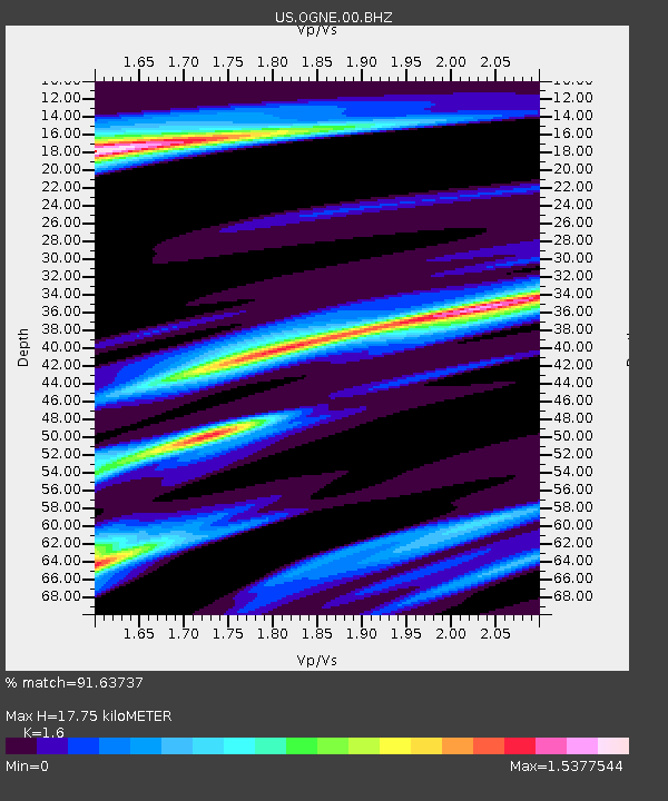
| Estimated Moho Depth: |
17.75 km |
| Estimated Crust Vp/Vs: |
1.60 |
| Assumed Crust Vp: |
6.483 km/s |
| Estimated Crust Vs: |
4.052 km/s |
| Estimated Crust Poisson's Ratio: |
0.18 |
|
| Radial Match: |
91.63737 % |
| Radial Bump: |
345 |
| Transverse Match: |
72.44503 % |
| Transverse Bump: |
360 |
| SOD ConfigId: |
1858631 |
| Insert Time: |
2016-12-08 18:49:13.961 +0000 |
| GWidth: |
2.5 |
| Max Bumps: |
400 |
| Tol: |
0.001 |
|
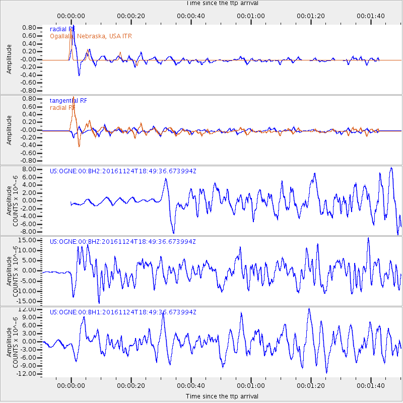
Signal To Noise
| Channel | StoN | STA | LTA |
| US:OGNE:00:BHZ:20161124T18:49:36.673994Z | 28.5943 | 7.2876333E-6 | 2.5486315E-7 |
| US:OGNE:00:BH1:20161124T18:49:36.673994Z | 5.653773 | 5.167768E-6 | 9.140389E-7 |
| US:OGNE:00:BH2:20161124T18:49:36.673994Z | 7.072418 | 4.323951E-6 | 6.1138223E-7 |
| Arrivals |
| Ps | 1.8 SECOND |
| PpPs | 6.5 SECOND |
| PsPs/PpSs | 8.3 SECOND |


