You are here: Home > Network List > TA - USArray Transportable Network (new EarthScope stations) Stations List
> Station C16A Fuhringer Ranch, Dutton, MT, USA > Earthquake Result Viewer
C16A Fuhringer Ranch, Dutton, MT, USA - Earthquake Result Viewer
| Earthquake location: |
Rat Islands, Aleutian Islands |
| Earthquake latitude/longitude: |
51.2/178.8 |
| Earthquake time(UTC): |
2008/05/20 (141) 13:53:35 GMT |
| Earthquake Depth: |
27 km |
| Earthquake Magnitude: |
5.8 MB, 6.0 MS, 6.3 MW, 6.3 MW |
| Earthquake Catalog/Contributor: |
WHDF/NEIC |
|
| Network: |
TA USArray Transportable Network (new EarthScope stations) |
| Station: |
C16A Fuhringer Ranch, Dutton, MT, USA |
| Lat/Lon: |
47.80 N/111.75 W |
| Elevation: |
1240 m |
|
| Distance: |
43.7 deg |
| Az: |
65.966 deg |
| Baz: |
301.459 deg |
| Ray Param: |
0.07230561 |
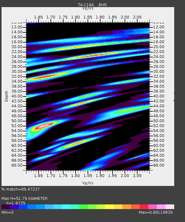
| Estimated Moho Depth: |
51.75 km |
| Estimated Crust Vp/Vs: |
1.67 |
| Assumed Crust Vp: |
6.306 km/s |
| Estimated Crust Vs: |
3.77 km/s |
| Estimated Crust Poisson's Ratio: |
0.22 |
|
| Radial Match: |
85.47237 % |
| Radial Bump: |
400 |
| Transverse Match: |
65.58296 % |
| Transverse Bump: |
400 |
| SOD ConfigId: |
2504 |
| Insert Time: |
2010-03-07 00:23:01.345 +0000 |
| GWidth: |
2.5 |
| Max Bumps: |
400 |
| Tol: |
0.001 |
|
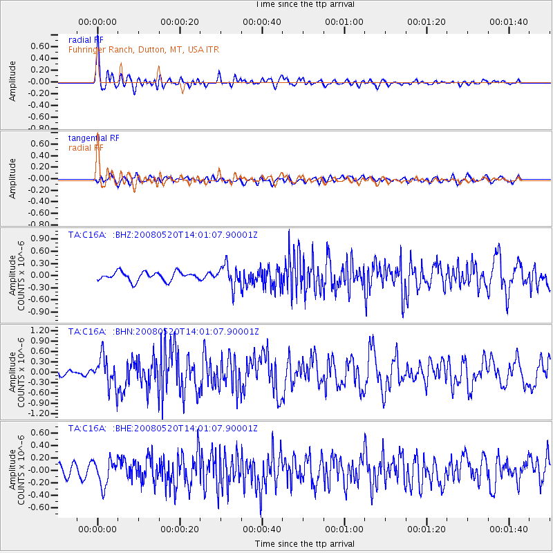
Signal To Noise
| Channel | StoN | STA | LTA |
| TA:C16A: :BHN:20080520T14:01:07.90001Z | 7.308915 | 4.5843703E-7 | 6.272299E-8 |
| TA:C16A: :BHE:20080520T14:01:07.90001Z | 2.4787097 | 2.0700287E-7 | 8.351235E-8 |
| TA:C16A: :BHZ:20080520T14:01:07.90001Z | 2.5148265 | 2.713794E-7 | 1.07911774E-7 |
| Arrivals |
| Ps | 5.9 SECOND |
| PpPs | 21 SECOND |
| PsPs/PpSs | 26 SECOND |


