You are here: Home > Network List > TA - USArray Transportable Network (new EarthScope stations) Stations List
> Station C16A Fuhringer Ranch, Dutton, MT, USA > Earthquake Result Viewer
C16A Fuhringer Ranch, Dutton, MT, USA - Earthquake Result Viewer
| Earthquake location: |
Tonga Islands |
| Earthquake latitude/longitude: |
-20.8/-173.3 |
| Earthquake time(UTC): |
2008/06/26 (178) 21:19:15 GMT |
| Earthquake Depth: |
38 km |
| Earthquake Magnitude: |
6.0 MB, 5.8 MS, 6.2 MW, 6.1 MW |
| Earthquake Catalog/Contributor: |
WHDF/NEIC |
|
| Network: |
TA USArray Transportable Network (new EarthScope stations) |
| Station: |
C16A Fuhringer Ranch, Dutton, MT, USA |
| Lat/Lon: |
47.80 N/111.75 W |
| Elevation: |
1240 m |
|
| Distance: |
87.7 deg |
| Az: |
36.405 deg |
| Baz: |
235.468 deg |
| Ray Param: |
0.04306497 |
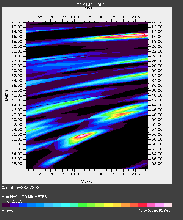
| Estimated Moho Depth: |
14.75 km |
| Estimated Crust Vp/Vs: |
2.09 |
| Assumed Crust Vp: |
6.306 km/s |
| Estimated Crust Vs: |
3.024 km/s |
| Estimated Crust Poisson's Ratio: |
0.35 |
|
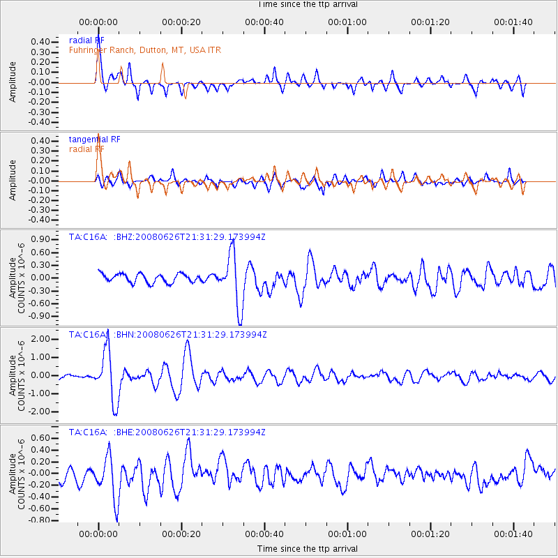
| Radial Match: |
88.07893 % |
| Radial Bump: |
400 |
| Transverse Match: |
66.27705 % |
| Transverse Bump: |
400 |
| SOD ConfigId: |
2504 |
| Insert Time: |
2010-03-07 00:23:13.654 +0000 |
| GWidth: |
2.5 |
| Max Bumps: |
400 |
| Tol: |
0.001 |
|
Signal To Noise
| Channel | StoN | STA | LTA |
| TA:C16A: :BHN:20080626T21:31:29.173994Z | 19.737413 | 1.444822E-6 | 7.3202195E-8 |
| TA:C16A: :BHE:20080626T21:31:29.173994Z | 3.2836385 | 3.8924236E-7 | 1.1853996E-7 |
| TA:C16A: :BHZ:20080626T21:31:29.173994Z | 6.305222 | 6.429859E-7 | 1.0197673E-7 |
| Arrivals |
| Ps | 2.6 SECOND |
| PpPs | 7.1 SECOND |
| PsPs/PpSs | 9.7 SECOND |


