You are here: Home > Network List > AV - Alaska Volcano Observatory Stations List
> Station MTBL Table Top, Makushin Volcano, Alaska > Earthquake Result Viewer
MTBL Table Top, Makushin Volcano, Alaska - Earthquake Result Viewer
| Earthquake location: |
Near Coast Of Northern Calif. |
| Earthquake latitude/longitude: |
40.3/-124.3 |
| Earthquake time(UTC): |
2019/06/23 (174) 03:53:02 GMT |
| Earthquake Depth: |
9.5 km |
| Earthquake Magnitude: |
5.6 mw |
| Earthquake Catalog/Contributor: |
NEIC PDE/nc |
|
| Network: |
AV Alaska Volcano Observatory |
| Station: |
MTBL Table Top, Makushin Volcano, Alaska |
| Lat/Lon: |
53.97 N/166.68 W |
| Elevation: |
810 m |
|
| Distance: |
31.4 deg |
| Az: |
310.167 deg |
| Baz: |
98.32 deg |
| Ray Param: |
0.07907719 |
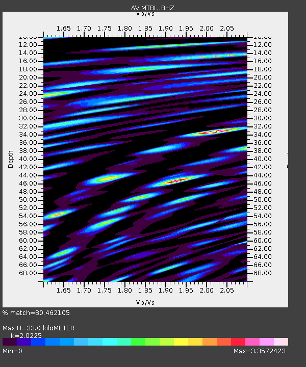
| Estimated Moho Depth: |
33.0 km |
| Estimated Crust Vp/Vs: |
2.02 |
| Assumed Crust Vp: |
3.943 km/s |
| Estimated Crust Vs: |
1.95 km/s |
| Estimated Crust Poisson's Ratio: |
0.34 |
|
| Radial Match: |
80.462105 % |
| Radial Bump: |
400 |
| Transverse Match: |
74.64566 % |
| Transverse Bump: |
400 |
| SOD ConfigId: |
18369291 |
| Insert Time: |
2019-07-07 03:53:30.266 +0000 |
| GWidth: |
2.5 |
| Max Bumps: |
400 |
| Tol: |
0.001 |
|

Signal To Noise
| Channel | StoN | STA | LTA |
| AV:MTBL: :BHZ:20190623T03:58:53.439998Z | 7.2974706 | 9.860648E-7 | 1.351242E-7 |
| AV:MTBL: :BHN:20190623T03:58:53.439998Z | 2.0327563 | 6.066324E-7 | 2.984285E-7 |
| AV:MTBL: :BHE:20190623T03:58:53.439998Z | 2.2401505 | 9.760843E-7 | 4.3572265E-7 |
| Arrivals |
| Ps | 8.8 SECOND |
| PpPs | 25 SECOND |
| PsPs/PpSs | 33 SECOND |


