You are here: Home > Network List > TA - USArray Transportable Network (new EarthScope stations) Stations List
> Station B18K Kokolik River, AK, USA > Earthquake Result Viewer
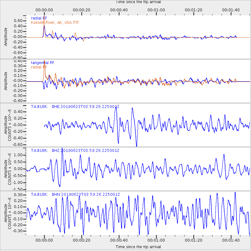
B18K Kokolik River, AK, USA - Earthquake Result Viewer
*The percent match for this event was below the threshold and hence no stack was calculated.
| Earthquake location: |
Near Coast Of Northern Calif. |
| Earthquake latitude/longitude: |
40.3/-124.3 |
| Earthquake time(UTC): |
2019/06/23 (174) 03:53:02 GMT |
| Earthquake Depth: |
9.5 km |
| Earthquake Magnitude: |
5.6 mw |
| Earthquake Catalog/Contributor: |
NEIC PDE/nc |
|
| Network: |
TA USArray Transportable Network (new EarthScope stations) |
| Station: |
B18K Kokolik River, AK, USA |
| Lat/Lon: |
69.36 N/161.80 W |
| Elevation: |
222 m |
|
| Distance: |
35.2 deg |
| Az: |
338.001 deg |
| Baz: |
126.064 deg |
| Ray Param: |
$rayparam |
*The percent match for this event was below the threshold and hence was not used in the summary stack. |
|
| Radial Match: |
78.64325 % |
| Radial Bump: |
400 |
| Transverse Match: |
68.92958 % |
| Transverse Bump: |
400 |
| SOD ConfigId: |
18369291 |
| Insert Time: |
2019-07-07 03:57:17.457 +0000 |
| GWidth: |
2.5 |
| Max Bumps: |
400 |
| Tol: |
0.001 |
|
Signal To Noise
| Channel | StoN | STA | LTA |
| TA:B18K: :BHZ:20190623T03:59:26.225001Z | 2.9341102 | 3.348581E-7 | 1.14125946E-7 |
| TA:B18K: :BHN:20190623T03:59:26.225001Z | 0.78468555 | 6.4007274E-8 | 8.1570604E-8 |
| TA:B18K: :BHE:20190623T03:59:26.225001Z | 1.7143167 | 1.2476735E-7 | 7.2779635E-8 |
| Arrivals |
| Ps | |
| PpPs | |
| PsPs/PpSs | |


