You are here: Home > Network List > TA - USArray Transportable Network (new EarthScope stations) Stations List
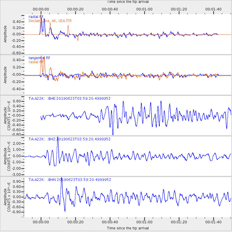
> Station A22K Sinclair Lake, AK, USA > Earthquake Result Viewer
A22K Sinclair Lake, AK, USA - Earthquake Result Viewer
| Earthquake location: |
Near Coast Of Northern Calif. |
| Earthquake latitude/longitude: |
40.3/-124.3 |
| Earthquake time(UTC): |
2019/06/23 (174) 03:53:02 GMT |
| Earthquake Depth: |
9.5 km |
| Earthquake Magnitude: |
5.6 mw |
| Earthquake Catalog/Contributor: |
NEIC PDE/nc |
|
| Network: |
TA USArray Transportable Network (new EarthScope stations) |
| Station: |
A22K Sinclair Lake, AK, USA |
| Lat/Lon: |
71.00 N/154.97 W |
| Elevation: |
6.0 m |
|
| Distance: |
34.5 deg |
| Az: |
342.852 deg |
| Baz: |
136.465 deg |
| Ray Param: |
0.0777026 |
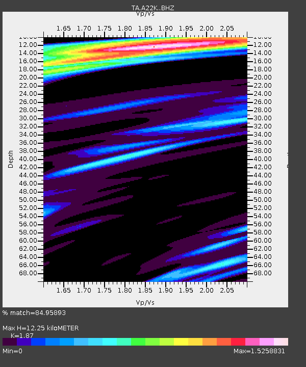
| Estimated Moho Depth: |
12.25 km |
| Estimated Crust Vp/Vs: |
1.87 |
| Assumed Crust Vp: |
5.782 km/s |
| Estimated Crust Vs: |
3.092 km/s |
| Estimated Crust Poisson's Ratio: |
0.30 |
|
| Radial Match: |
84.95893 % |
| Radial Bump: |
400 |
| Transverse Match: |
76.33485 % |
| Transverse Bump: |
400 |
| SOD ConfigId: |
18369291 |
| Insert Time: |
2019-07-07 03:57:17.412 +0000 |
| GWidth: |
2.5 |
| Max Bumps: |
400 |
| Tol: |
0.001 |
|
Signal To Noise
| Channel | StoN | STA | LTA |
| TA:A22K: :BHZ:20190623T03:59:20.499995Z | 3.8589594 | 4.2596952E-7 | 1.10384555E-7 |
| TA:A22K: :BHN:20190623T03:59:20.499995Z | 1.6373749 | 1.262297E-7 | 7.709273E-8 |
| TA:A22K: :BHE:20190623T03:59:20.499995Z | 1.7575688 | 1.0901637E-7 | 6.20268E-8 |
| Arrivals |
| Ps | 2.0 SECOND |
| PpPs | 5.7 SECOND |
| PsPs/PpSs | 7.7 SECOND |


