You are here: Home > Network List > TA - USArray Transportable Network (new EarthScope stations) Stations List
> Station B21K Ikpikpuk River, AK, USA > Earthquake Result Viewer
B21K Ikpikpuk River, AK, USA - Earthquake Result Viewer
| Earthquake location: |
Near Coast Of Northern Calif. |
| Earthquake latitude/longitude: |
40.3/-124.3 |
| Earthquake time(UTC): |
2019/06/23 (174) 03:53:02 GMT |
| Earthquake Depth: |
9.5 km |
| Earthquake Magnitude: |
5.6 mw |
| Earthquake Catalog/Contributor: |
NEIC PDE/nc |
|
| Network: |
TA USArray Transportable Network (new EarthScope stations) |
| Station: |
B21K Ikpikpuk River, AK, USA |
| Lat/Lon: |
69.62 N/154.61 W |
| Elevation: |
92 m |
|
| Distance: |
33.4 deg |
| Az: |
341.282 deg |
| Baz: |
135.503 deg |
| Ray Param: |
0.0782116 |
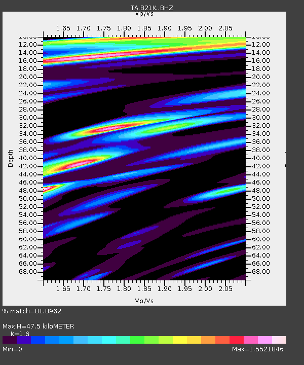
| Estimated Moho Depth: |
47.5 km |
| Estimated Crust Vp/Vs: |
1.60 |
| Assumed Crust Vp: |
6.221 km/s |
| Estimated Crust Vs: |
3.888 km/s |
| Estimated Crust Poisson's Ratio: |
0.18 |
|
| Radial Match: |
81.8962 % |
| Radial Bump: |
400 |
| Transverse Match: |
71.99113 % |
| Transverse Bump: |
400 |
| SOD ConfigId: |
18369291 |
| Insert Time: |
2019-07-07 03:57:18.503 +0000 |
| GWidth: |
2.5 |
| Max Bumps: |
400 |
| Tol: |
0.001 |
|

Signal To Noise
| Channel | StoN | STA | LTA |
| TA:B21K: :BHZ:20190623T03:59:11.100001Z | 3.9688537 | 2.7317748E-7 | 6.883032E-8 |
| TA:B21K: :BHN:20190623T03:59:11.100001Z | 0.97151244 | 5.810881E-8 | 5.981273E-8 |
| TA:B21K: :BHE:20190623T03:59:11.100001Z | 1.1594785 | 6.9013375E-8 | 5.9521042E-8 |
| Arrivals |
| Ps | 5.0 SECOND |
| PpPs | 18 SECOND |
| PsPs/PpSs | 23 SECOND |


