You are here: Home > Network List > TA - USArray Transportable Network (new EarthScope stations) Stations List
> Station E19K Redstone River, AK, USA > Earthquake Result Viewer
E19K Redstone River, AK, USA - Earthquake Result Viewer
| Earthquake location: |
Near Coast Of Northern Calif. |
| Earthquake latitude/longitude: |
40.3/-124.3 |
| Earthquake time(UTC): |
2019/06/23 (174) 03:53:02 GMT |
| Earthquake Depth: |
9.5 km |
| Earthquake Magnitude: |
5.6 mw |
| Earthquake Catalog/Contributor: |
NEIC PDE/nc |
|
| Network: |
TA USArray Transportable Network (new EarthScope stations) |
| Station: |
E19K Redstone River, AK, USA |
| Lat/Lon: |
67.46 N/157.23 W |
| Elevation: |
441 m |
|
| Distance: |
32.7 deg |
| Az: |
337.15 deg |
| Baz: |
129.604 deg |
| Ray Param: |
0.07855375 |
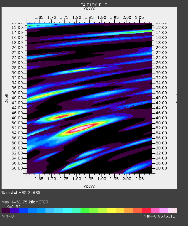
| Estimated Moho Depth: |
51.75 km |
| Estimated Crust Vp/Vs: |
1.82 |
| Assumed Crust Vp: |
6.577 km/s |
| Estimated Crust Vs: |
3.614 km/s |
| Estimated Crust Poisson's Ratio: |
0.28 |
|
| Radial Match: |
85.34685 % |
| Radial Bump: |
355 |
| Transverse Match: |
69.74648 % |
| Transverse Bump: |
400 |
| SOD ConfigId: |
18369291 |
| Insert Time: |
2019-07-07 03:57:29.924 +0000 |
| GWidth: |
2.5 |
| Max Bumps: |
400 |
| Tol: |
0.001 |
|

Signal To Noise
| Channel | StoN | STA | LTA |
| TA:E19K: :BHZ:20190623T03:59:04.475001Z | 5.719752 | 2.4778802E-7 | 4.3321464E-8 |
| TA:E19K: :BHN:20190623T03:59:04.475001Z | 1.9480163 | 7.016184E-8 | 3.601707E-8 |
| TA:E19K: :BHE:20190623T03:59:04.475001Z | 3.0088632 | 9.4523415E-8 | 3.141499E-8 |
| Arrivals |
| Ps | 7.0 SECOND |
| PpPs | 20 SECOND |
| PsPs/PpSs | 27 SECOND |


