You are here: Home > Network List > TA - USArray Transportable Network (new EarthScope stations) Stations List
> Station F17K Baldwin Penninsula, AK, USA > Earthquake Result Viewer
F17K Baldwin Penninsula, AK, USA - Earthquake Result Viewer
| Earthquake location: |
Near Coast Of Northern Calif. |
| Earthquake latitude/longitude: |
40.3/-124.3 |
| Earthquake time(UTC): |
2019/06/23 (174) 03:53:02 GMT |
| Earthquake Depth: |
9.5 km |
| Earthquake Magnitude: |
5.6 mw |
| Earthquake Catalog/Contributor: |
NEIC PDE/nc |
|
| Network: |
TA USArray Transportable Network (new EarthScope stations) |
| Station: |
F17K Baldwin Penninsula, AK, USA |
| Lat/Lon: |
66.44 N/161.25 W |
| Elevation: |
51 m |
|
| Distance: |
33.3 deg |
| Az: |
333.92 deg |
| Baz: |
123.201 deg |
| Ray Param: |
0.07825398 |
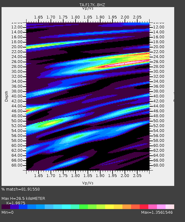
| Estimated Moho Depth: |
26.5 km |
| Estimated Crust Vp/Vs: |
2.00 |
| Assumed Crust Vp: |
6.276 km/s |
| Estimated Crust Vs: |
3.142 km/s |
| Estimated Crust Poisson's Ratio: |
0.33 |
|
| Radial Match: |
81.91558 % |
| Radial Bump: |
400 |
| Transverse Match: |
68.25642 % |
| Transverse Bump: |
400 |
| SOD ConfigId: |
18369291 |
| Insert Time: |
2019-07-07 03:57:35.230 +0000 |
| GWidth: |
2.5 |
| Max Bumps: |
400 |
| Tol: |
0.001 |
|

Signal To Noise
| Channel | StoN | STA | LTA |
| TA:F17K: :BHZ:20190623T03:59:10.300013Z | 3.838614 | 3.2949623E-7 | 8.583729E-8 |
| TA:F17K: :BHN:20190623T03:59:10.300013Z | 1.1556433 | 1.1777179E-7 | 1.0191015E-7 |
| TA:F17K: :BHE:20190623T03:59:10.300013Z | 2.1080005 | 2.2791723E-7 | 1.0812009E-7 |
| Arrivals |
| Ps | 4.5 SECOND |
| PpPs | 12 SECOND |
| PsPs/PpSs | 16 SECOND |


