You are here: Home > Network List > TA - USArray Transportable Network (new EarthScope stations) Stations List
> Station F18K Selawik, AK, USA > Earthquake Result Viewer
F18K Selawik, AK, USA - Earthquake Result Viewer
| Earthquake location: |
Near Coast Of Northern Calif. |
| Earthquake latitude/longitude: |
40.3/-124.3 |
| Earthquake time(UTC): |
2019/06/23 (174) 03:53:02 GMT |
| Earthquake Depth: |
9.5 km |
| Earthquake Magnitude: |
5.6 mw |
| Earthquake Catalog/Contributor: |
NEIC PDE/nc |
|
| Network: |
TA USArray Transportable Network (new EarthScope stations) |
| Station: |
F18K Selawik, AK, USA |
| Lat/Lon: |
66.60 N/159.65 W |
| Elevation: |
27 m |
|
| Distance: |
32.9 deg |
| Az: |
334.821 deg |
| Baz: |
125.42 deg |
| Ray Param: |
0.078456305 |
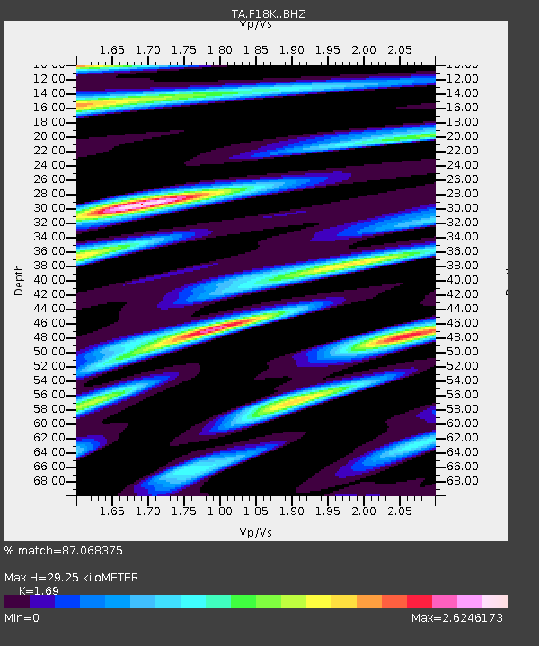
| Estimated Moho Depth: |
29.25 km |
| Estimated Crust Vp/Vs: |
1.69 |
| Assumed Crust Vp: |
6.577 km/s |
| Estimated Crust Vs: |
3.892 km/s |
| Estimated Crust Poisson's Ratio: |
0.23 |
|
| Radial Match: |
87.068375 % |
| Radial Bump: |
400 |
| Transverse Match: |
68.012535 % |
| Transverse Bump: |
400 |
| SOD ConfigId: |
18369291 |
| Insert Time: |
2019-07-07 03:57:35.537 +0000 |
| GWidth: |
2.5 |
| Max Bumps: |
400 |
| Tol: |
0.001 |
|

Signal To Noise
| Channel | StoN | STA | LTA |
| TA:F18K: :BHZ:20190623T03:59:06.475001Z | 3.0302866 | 2.451101E-7 | 8.088677E-8 |
| TA:F18K: :BHN:20190623T03:59:06.475001Z | 1.1228182 | 1.0444894E-7 | 9.302391E-8 |
| TA:F18K: :BHE:20190623T03:59:06.475001Z | 0.91196036 | 9.564088E-8 | 1.0487395E-7 |
| Arrivals |
| Ps | 3.3 SECOND |
| PpPs | 11 SECOND |
| PsPs/PpSs | 14 SECOND |


