You are here: Home > Network List > TA - USArray Transportable Network (new EarthScope stations) Stations List
> Station C16A Fuhringer Ranch, Dutton, MT, USA > Earthquake Result Viewer
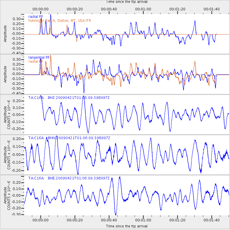
C16A Fuhringer Ranch, Dutton, MT, USA - Earthquake Result Viewer
*The percent match for this event was below the threshold and hence no stack was calculated.
| Earthquake location: |
Vanuatu Islands |
| Earthquake latitude/longitude: |
-19.8/169.9 |
| Earthquake time(UTC): |
2009/04/21 (111) 00:53:13 GMT |
| Earthquake Depth: |
36 km |
| Earthquake Magnitude: |
5.6 MB, 5.3 MS, 5.8 MW, 5.6 MW |
| Earthquake Catalog/Contributor: |
WHDF/NEIC |
|
| Network: |
TA USArray Transportable Network (new EarthScope stations) |
| Station: |
C16A Fuhringer Ranch, Dutton, MT, USA |
| Lat/Lon: |
47.80 N/111.75 W |
| Elevation: |
1240 m |
|
| Distance: |
96.9 deg |
| Az: |
41.682 deg |
| Baz: |
248.27 deg |
| Ray Param: |
$rayparam |
*The percent match for this event was below the threshold and hence was not used in the summary stack. |
|
| Radial Match: |
41.01356 % |
| Radial Bump: |
400 |
| Transverse Match: |
55.35946 % |
| Transverse Bump: |
400 |
| SOD ConfigId: |
2658 |
| Insert Time: |
2010-03-07 00:24:19.099 +0000 |
| GWidth: |
2.5 |
| Max Bumps: |
400 |
| Tol: |
0.001 |
|
Signal To Noise
| Channel | StoN | STA | LTA |
| TA:C16A: :BHN:20090421T01:06:09.398997Z | 2.061886 | 1.4789198E-7 | 7.172656E-8 |
| TA:C16A: :BHE:20090421T01:06:09.398997Z | 1.6158625 | 1.0452109E-7 | 6.468439E-8 |
| TA:C16A: :BHZ:20090421T01:06:09.398997Z | 0.89422697 | 9.011318E-8 | 1.00772155E-7 |
| Arrivals |
| Ps | |
| PpPs | |
| PsPs/PpSs | |


