You are here: Home > Network List > TA - USArray Transportable Network (new EarthScope stations) Stations List
> Station C16A Fuhringer Ranch, Dutton, MT, USA > Earthquake Result Viewer
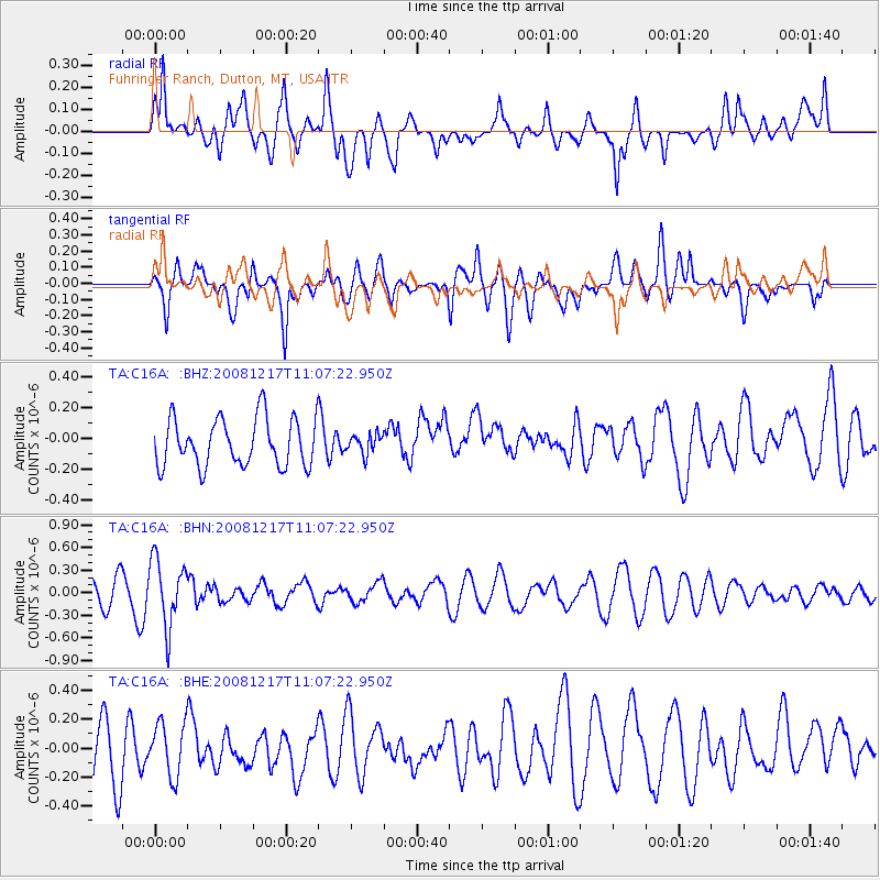
C16A Fuhringer Ranch, Dutton, MT, USA - Earthquake Result Viewer
*The percent match for this event was below the threshold and hence no stack was calculated.
| Earthquake location: |
Fiji Islands Region |
| Earthquake latitude/longitude: |
-17.7/-178.4 |
| Earthquake time(UTC): |
2008/12/17 (352) 10:55:59 GMT |
| Earthquake Depth: |
530 km |
| Earthquake Magnitude: |
5.8 MW, 5.2 MB, 5.8 MW |
| Earthquake Catalog/Contributor: |
WHDF/NEIC |
|
| Network: |
TA USArray Transportable Network (new EarthScope stations) |
| Station: |
C16A Fuhringer Ranch, Dutton, MT, USA |
| Lat/Lon: |
47.80 N/111.75 W |
| Elevation: |
1240 m |
|
| Distance: |
88.2 deg |
| Az: |
38.254 deg |
| Baz: |
241.072 deg |
| Ray Param: |
$rayparam |
*The percent match for this event was below the threshold and hence was not used in the summary stack. |
|
| Radial Match: |
59.505302 % |
| Radial Bump: |
400 |
| Transverse Match: |
58.009773 % |
| Transverse Bump: |
400 |
| SOD ConfigId: |
2658 |
| Insert Time: |
2010-03-07 00:24:21.834 +0000 |
| GWidth: |
2.5 |
| Max Bumps: |
400 |
| Tol: |
0.001 |
|
Signal To Noise
| Channel | StoN | STA | LTA |
| TA:C16A: :BHN:20081217T11:07:22.950Z | 3.0710886 | 4.3987066E-7 | 1.4322956E-7 |
| TA:C16A: :BHE:20081217T11:07:22.950Z | 0.9534611 | 1.8184262E-7 | 1.9071844E-7 |
| TA:C16A: :BHZ:20081217T11:07:22.950Z | 0.394615 | 6.1464675E-8 | 1.557586E-7 |
| Arrivals |
| Ps | |
| PpPs | |
| PsPs/PpSs | |


