You are here: Home > Network List > UU - University of Utah Regional Network Stations List
> Station FOR3 Blundell North, UT, USA > Earthquake Result Viewer
FOR3 Blundell North, UT, USA - Earthquake Result Viewer
| Earthquake location: |
Off Coast Of Central America |
| Earthquake latitude/longitude: |
12.0/-88.8 |
| Earthquake time(UTC): |
2016/11/24 (329) 18:43:48 GMT |
| Earthquake Depth: |
10 km |
| Earthquake Magnitude: |
7.0 MWW, 6.7 MWB, 7.2 MI |
| Earthquake Catalog/Contributor: |
NEIC PDE/NEIC COMCAT |
|
| Network: |
UU University of Utah Regional Network |
| Station: |
FOR3 Blundell North, UT, USA |
| Lat/Lon: |
38.51 N/112.88 W |
| Elevation: |
1699 m |
|
| Distance: |
34.0 deg |
| Az: |
325.166 deg |
| Baz: |
134.561 deg |
| Ray Param: |
0.07793469 |
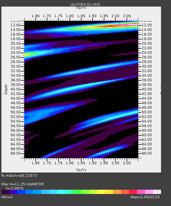
| Estimated Moho Depth: |
11.25 km |
| Estimated Crust Vp/Vs: |
2.10 |
| Assumed Crust Vp: |
6.276 km/s |
| Estimated Crust Vs: |
2.992 km/s |
| Estimated Crust Poisson's Ratio: |
0.35 |
|
| Radial Match: |
88.22573 % |
| Radial Bump: |
400 |
| Transverse Match: |
70.381004 % |
| Transverse Bump: |
400 |
| SOD ConfigId: |
1858631 |
| Insert Time: |
2016-12-08 18:50:38.261 +0000 |
| GWidth: |
2.5 |
| Max Bumps: |
400 |
| Tol: |
0.001 |
|

Signal To Noise
| Channel | StoN | STA | LTA |
| UU:FOR3:01:HHZ:20161124T18:50:02.099989Z | 15.482221 | 1.5787863E-7 | 1.0197415E-8 |
| UU:FOR3:01:HHN:20161124T18:50:02.099989Z | 8.8693495 | 7.39744E-8 | 8.3404545E-9 |
| UU:FOR3:01:HHE:20161124T18:50:02.099989Z | 7.0675287 | 5.835508E-8 | 8.256787E-9 |
| Arrivals |
| Ps | 2.1 SECOND |
| PpPs | 5.2 SECOND |
| PsPs/PpSs | 7.3 SECOND |


