You are here: Home > Network List > TA - USArray Transportable Network (new EarthScope stations) Stations List
> Station C16A Fuhringer Ranch, Dutton, MT, USA > Earthquake Result Viewer
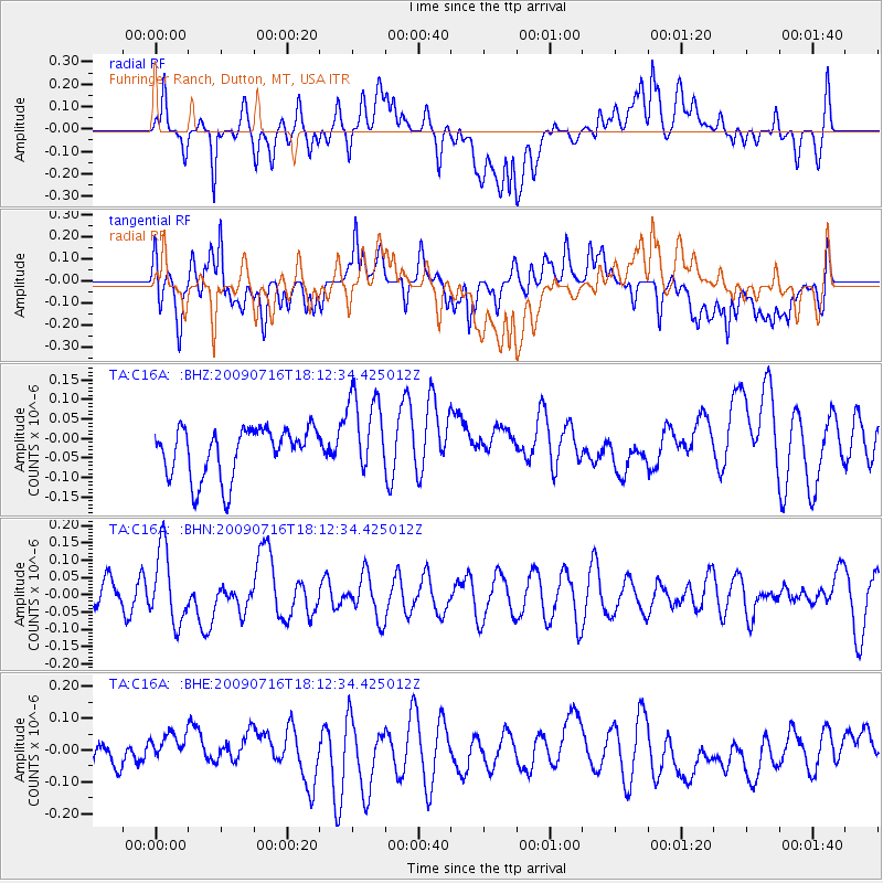
C16A Fuhringer Ranch, Dutton, MT, USA - Earthquake Result Viewer
*The percent match for this event was below the threshold and hence no stack was calculated.
| Earthquake location: |
Vanuatu Islands |
| Earthquake latitude/longitude: |
-17.5/167.7 |
| Earthquake time(UTC): |
2009/07/16 (197) 17:59:36 GMT |
| Earthquake Depth: |
10 km |
| Earthquake Magnitude: |
5.8 MW, 5.4 MS, 5.4 MB, 5.8 MW |
| Earthquake Catalog/Contributor: |
WHDF/NEIC |
|
| Network: |
TA USArray Transportable Network (new EarthScope stations) |
| Station: |
C16A Fuhringer Ranch, Dutton, MT, USA |
| Lat/Lon: |
47.80 N/111.75 W |
| Elevation: |
1240 m |
|
| Distance: |
96.6 deg |
| Az: |
42.026 deg |
| Baz: |
251.342 deg |
| Ray Param: |
$rayparam |
*The percent match for this event was below the threshold and hence was not used in the summary stack. |
|
| Radial Match: |
39.552425 % |
| Radial Bump: |
400 |
| Transverse Match: |
41.569588 % |
| Transverse Bump: |
400 |
| SOD ConfigId: |
2648 |
| Insert Time: |
2010-03-07 00:24:36.785 +0000 |
| GWidth: |
2.5 |
| Max Bumps: |
400 |
| Tol: |
0.001 |
|
Signal To Noise
| Channel | StoN | STA | LTA |
| TA:C16A: :BHN:20090716T18:12:34.425012Z | 2.3028586 | 1.0658761E-7 | 4.6284914E-8 |
| TA:C16A: :BHE:20090716T18:12:34.425012Z | 0.77981675 | 4.546643E-8 | 5.830399E-8 |
| TA:C16A: :BHZ:20090716T18:12:34.425012Z | 1.7246699 | 1.07796254E-7 | 6.250254E-8 |
| Arrivals |
| Ps | |
| PpPs | |
| PsPs/PpSs | |


