You are here: Home > Network List > TA - USArray Transportable Network (new EarthScope stations) Stations List
> Station A14A Double T Ranch, Babb, MT, USA > Earthquake Result Viewer
A14A Double T Ranch, Babb, MT, USA - Earthquake Result Viewer
| Earthquake location: |
Santa Cruz Islands Region |
| Earthquake latitude/longitude: |
-11.0/164.5 |
| Earthquake time(UTC): |
2008/07/19 (201) 09:27:01 GMT |
| Earthquake Depth: |
11 km |
| Earthquake Magnitude: |
6.1 MB, 6.4 MS, 6.6 MW, 6.6 MW |
| Earthquake Catalog/Contributor: |
WHDF/NEIC |
|
| Network: |
TA USArray Transportable Network (new EarthScope stations) |
| Station: |
A14A Double T Ranch, Babb, MT, USA |
| Lat/Lon: |
48.97 N/113.42 W |
| Elevation: |
1420 m |
|
| Distance: |
93.1 deg |
| Az: |
40.814 deg |
| Baz: |
256.856 deg |
| Ray Param: |
0.041327454 |
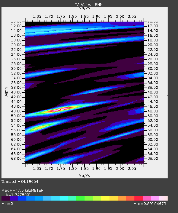
| Estimated Moho Depth: |
47.0 km |
| Estimated Crust Vp/Vs: |
1.75 |
| Assumed Crust Vp: |
6.178 km/s |
| Estimated Crust Vs: |
3.535 km/s |
| Estimated Crust Poisson's Ratio: |
0.26 |
|
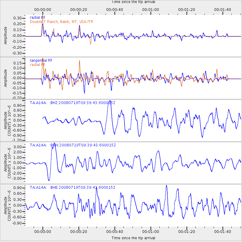
| Radial Match: |
84.19654 % |
| Radial Bump: |
400 |
| Transverse Match: |
73.9567 % |
| Transverse Bump: |
400 |
| SOD ConfigId: |
2658 |
| Insert Time: |
2010-03-07 00:25:51.155 +0000 |
| GWidth: |
2.5 |
| Max Bumps: |
400 |
| Tol: |
0.001 |
|
Signal To Noise
| Channel | StoN | STA | LTA |
| TA:A14A: :BHN:20080719T09:39:43.600015Z | 17.301003 | 1.554331E-6 | 8.984051E-8 |
| TA:A14A: :BHE:20080719T09:39:43.600015Z | 1.0813916 | 1.0802641E-7 | 9.9895736E-8 |
| TA:A14A: :BHZ:20080719T09:39:43.600015Z | 3.1729834 | 3.7479612E-7 | 1.1812104E-7 |
| Arrivals |
| Ps | 5.8 SECOND |
| PpPs | 21 SECOND |
| PsPs/PpSs | 26 SECOND |


