You are here: Home > Network List > TA - USArray Transportable Network (new EarthScope stations) Stations List
> Station A14A Double T Ranch, Babb, MT, USA > Earthquake Result Viewer
A14A Double T Ranch, Babb, MT, USA - Earthquake Result Viewer
| Earthquake location: |
Santa Cruz Islands |
| Earthquake latitude/longitude: |
-11.6/166.1 |
| Earthquake time(UTC): |
2009/08/10 (222) 04:06:31 GMT |
| Earthquake Depth: |
35 km |
| Earthquake Magnitude: |
5.8 MB, 6.3 MS, 6.6 MW, 6.6 MW |
| Earthquake Catalog/Contributor: |
WHDF/NEIC |
|
| Network: |
TA USArray Transportable Network (new EarthScope stations) |
| Station: |
A14A Double T Ranch, Babb, MT, USA |
| Lat/Lon: |
48.97 N/113.42 W |
| Elevation: |
1420 m |
|
| Distance: |
92.5 deg |
| Az: |
40.579 deg |
| Baz: |
255.297 deg |
| Ray Param: |
0.041432843 |
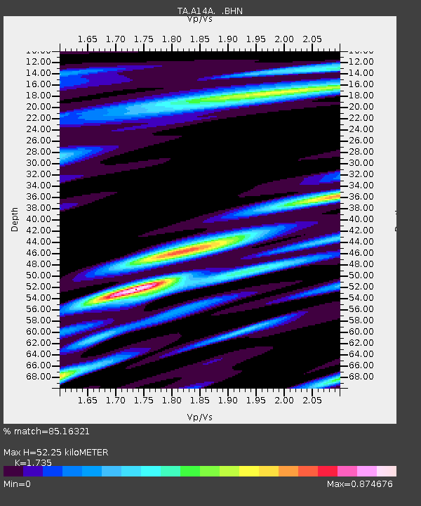
| Estimated Moho Depth: |
52.25 km |
| Estimated Crust Vp/Vs: |
1.74 |
| Assumed Crust Vp: |
6.178 km/s |
| Estimated Crust Vs: |
3.561 km/s |
| Estimated Crust Poisson's Ratio: |
0.25 |
|
| Radial Match: |
85.16321 % |
| Radial Bump: |
400 |
| Transverse Match: |
77.38667 % |
| Transverse Bump: |
356 |
| SOD ConfigId: |
2622 |
| Insert Time: |
2010-03-07 00:25:56.353 +0000 |
| GWidth: |
2.5 |
| Max Bumps: |
400 |
| Tol: |
0.001 |
|

Signal To Noise
| Channel | StoN | STA | LTA |
| TA:A14A: :BHN:20090810T04:19:07.200012Z | 5.408399 | 6.246591E-7 | 1.1549796E-7 |
| TA:A14A: :BHE:20090810T04:19:07.200012Z | 1.1573167 | 8.6643E-8 | 7.486542E-8 |
| TA:A14A: :BHZ:20090810T04:19:07.200012Z | 1.9283515 | 1.7309523E-7 | 8.9763326E-8 |
| Arrivals |
| Ps | 6.3 SECOND |
| PpPs | 23 SECOND |
| PsPs/PpSs | 29 SECOND |


