You are here: Home > Network List > TA - USArray Transportable Network (new EarthScope stations) Stations List
> Station E18K Tukpahlearik Creek, AK, USA > Earthquake Result Viewer
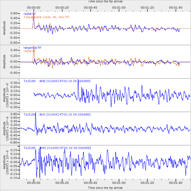
E18K Tukpahlearik Creek, AK, USA - Earthquake Result Viewer
*The percent match for this event was below the threshold and hence no stack was calculated.
| Earthquake location: |
Near East Coast Of Honshu, Japan |
| Earthquake latitude/longitude: |
34.9/140.0 |
| Earthquake time(UTC): |
2019/06/24 (175) 00:11:45 GMT |
| Earthquake Depth: |
48 km |
| Earthquake Magnitude: |
5.2 Mww |
| Earthquake Catalog/Contributor: |
NEIC PDE/us |
|
| Network: |
TA USArray Transportable Network (new EarthScope stations) |
| Station: |
E18K Tukpahlearik Creek, AK, USA |
| Lat/Lon: |
67.42 N/160.60 W |
| Elevation: |
297 m |
|
| Distance: |
46.6 deg |
| Az: |
27.222 deg |
| Baz: |
256.797 deg |
| Ray Param: |
$rayparam |
*The percent match for this event was below the threshold and hence was not used in the summary stack. |
|
| Radial Match: |
64.05277 % |
| Radial Bump: |
400 |
| Transverse Match: |
59.22124 % |
| Transverse Bump: |
400 |
| SOD ConfigId: |
18369291 |
| Insert Time: |
2019-07-08 00:18:52.799 +0000 |
| GWidth: |
2.5 |
| Max Bumps: |
400 |
| Tol: |
0.001 |
|
Signal To Noise
| Channel | StoN | STA | LTA |
| TA:E18K: :BHZ:20190624T00:19:38.099988Z | 7.415852 | 2.6100068E-7 | 3.519497E-8 |
| TA:E18K: :BHN:20190624T00:19:38.099988Z | 3.0205138 | 9.7627016E-8 | 3.2321328E-8 |
| TA:E18K: :BHE:20190624T00:19:38.099988Z | 4.293141 | 1.3550827E-7 | 3.15639E-8 |
| Arrivals |
| Ps | |
| PpPs | |
| PsPs/PpSs | |


