You are here: Home > Network List > TA - USArray Transportable Network (new EarthScope stations) Stations List
> Station A14A Double T Ranch, Babb, MT, USA > Earthquake Result Viewer
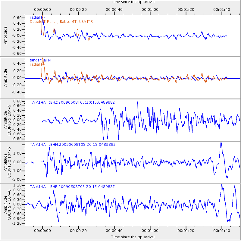
A14A Double T Ranch, Babb, MT, USA - Earthquake Result Viewer

| Earthquake location: |
Honduras |
| Earthquake latitude/longitude: |
15.8/-86.9 |
| Earthquake time(UTC): |
2009/06/08 (159) 05:13:14 GMT |
| Earthquake Depth: |
10 km |
| Earthquake Magnitude: |
5.5 MB, 4.9 MS, 5.4 MW, 5.4 MW |
| Earthquake Catalog/Contributor: |
WHDF/NEIC |
|
| Network: |
TA USArray Transportable Network (new EarthScope stations) |
| Station: |
A14A Double T Ranch, Babb, MT, USA |
| Lat/Lon: |
48.97 N/113.42 W |
| Elevation: |
1420 m |
|
| Distance: |
39.6 deg |
| Az: |
332.452 deg |
| Baz: |
137.49 deg |
| Ray Param: |
0.0749097 |
| Estimated Moho Depth: |
62.5 km |
| Estimated Crust Vp/Vs: |
1.63 |
| Assumed Crust Vp: |
6.178 km/s |
| Estimated Crust Vs: |
3.779 km/s |
| Estimated Crust Poisson's Ratio: |
0.20 |
|
| Radial Match: |
90.056564 % |
| Radial Bump: |
374 |
| Transverse Match: |
58.39459 % |
| Transverse Bump: |
400 |
| SOD ConfigId: |
2648 |
| Insert Time: |
2010-03-07 00:26:11.585 +0000 |
| GWidth: |
2.5 |
| Max Bumps: |
400 |
| Tol: |
0.001 |
|
Signal To Noise
| Channel | StoN | STA | LTA |
| TA:A14A: :BHN:20090608T05:20:15.048988Z | 9.931069 | 8.132343E-7 | 8.188789E-8 |
| TA:A14A: :BHE:20090608T05:20:15.048988Z | 2.3884125 | 2.1494367E-7 | 8.999437E-8 |
| TA:A14A: :BHZ:20090608T05:20:15.048988Z | 3.6538963 | 3.1550135E-7 | 8.634655E-8 |
| Arrivals |
| Ps | 6.9 SECOND |
| PpPs | 25 SECOND |
| PsPs/PpSs | 32 SECOND |


