You are here: Home > Network List > TA - USArray Transportable Network (new EarthScope stations) Stations List
> Station G21K Allakaket, AK, USA > Earthquake Result Viewer
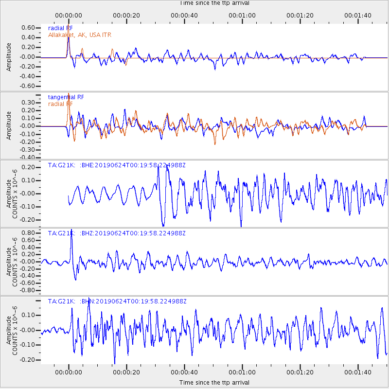
G21K Allakaket, AK, USA - Earthquake Result Viewer
*The percent match for this event was below the threshold and hence no stack was calculated.
| Earthquake location: |
Near East Coast Of Honshu, Japan |
| Earthquake latitude/longitude: |
34.9/140.0 |
| Earthquake time(UTC): |
2019/06/24 (175) 00:11:45 GMT |
| Earthquake Depth: |
48 km |
| Earthquake Magnitude: |
5.2 Mww |
| Earthquake Catalog/Contributor: |
NEIC PDE/us |
|
| Network: |
TA USArray Transportable Network (new EarthScope stations) |
| Station: |
G21K Allakaket, AK, USA |
| Lat/Lon: |
66.52 N/153.51 W |
| Elevation: |
446 m |
|
| Distance: |
49.2 deg |
| Az: |
29.039 deg |
| Baz: |
264.542 deg |
| Ray Param: |
$rayparam |
*The percent match for this event was below the threshold and hence was not used in the summary stack. |
|
| Radial Match: |
69.018196 % |
| Radial Bump: |
400 |
| Transverse Match: |
57.311817 % |
| Transverse Bump: |
400 |
| SOD ConfigId: |
18369291 |
| Insert Time: |
2019-07-08 00:19:09.743 +0000 |
| GWidth: |
2.5 |
| Max Bumps: |
400 |
| Tol: |
0.001 |
|
Signal To Noise
| Channel | StoN | STA | LTA |
| TA:G21K: :BHZ:20190624T00:19:58.224988Z | 7.6331944 | 3.0760293E-7 | 4.0298062E-8 |
| TA:G21K: :BHN:20190624T00:19:58.224988Z | 2.2441268 | 7.876359E-8 | 3.509766E-8 |
| TA:G21K: :BHE:20190624T00:19:58.224988Z | 3.3019078 | 1.4954959E-7 | 4.529187E-8 |
| Arrivals |
| Ps | |
| PpPs | |
| PsPs/PpSs | |


