You are here: Home > Network List > TA - USArray Transportable Network (new EarthScope stations) Stations List
> Station I30M Mount Dempster, Yukon, CAN > Earthquake Result Viewer
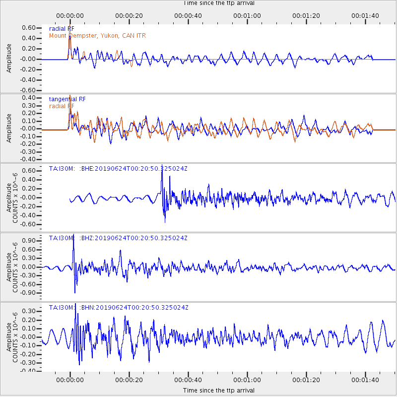
I30M Mount Dempster, Yukon, CAN - Earthquake Result Viewer
*The percent match for this event was below the threshold and hence no stack was calculated.
| Earthquake location: |
Near East Coast Of Honshu, Japan |
| Earthquake latitude/longitude: |
34.9/140.0 |
| Earthquake time(UTC): |
2019/06/24 (175) 00:11:45 GMT |
| Earthquake Depth: |
48 km |
| Earthquake Magnitude: |
5.2 Mww |
| Earthquake Catalog/Contributor: |
NEIC PDE/us |
|
| Network: |
TA USArray Transportable Network (new EarthScope stations) |
| Station: |
I30M Mount Dempster, Yukon, CAN |
| Lat/Lon: |
65.22 N/136.38 W |
| Elevation: |
1399 m |
|
| Distance: |
56.3 deg |
| Az: |
30.233 deg |
| Baz: |
280.901 deg |
| Ray Param: |
$rayparam |
*The percent match for this event was below the threshold and hence was not used in the summary stack. |
|
| Radial Match: |
60.383392 % |
| Radial Bump: |
400 |
| Transverse Match: |
60.393925 % |
| Transverse Bump: |
400 |
| SOD ConfigId: |
18369291 |
| Insert Time: |
2019-07-08 00:19:25.249 +0000 |
| GWidth: |
2.5 |
| Max Bumps: |
400 |
| Tol: |
0.001 |
|
Signal To Noise
| Channel | StoN | STA | LTA |
| TA:I30M: :BHZ:20190624T00:20:50.325024Z | 7.501798 | 3.4036594E-7 | 4.5371248E-8 |
| TA:I30M: :BHN:20190624T00:20:50.325024Z | 1.9107543 | 1.5332941E-7 | 8.0245485E-8 |
| TA:I30M: :BHE:20190624T00:20:50.325024Z | 4.8182745 | 2.4281903E-7 | 5.039543E-8 |
| Arrivals |
| Ps | |
| PpPs | |
| PsPs/PpSs | |


