You are here: Home > Network List > AK - Alaska Regional Network Stations List
> Station DHY Denali Highway > Earthquake Result Viewer
DHY Denali Highway - Earthquake Result Viewer
| Earthquake location: |
Irian Jaya, Indonesia |
| Earthquake latitude/longitude: |
-2.9/138.5 |
| Earthquake time(UTC): |
2019/06/24 (175) 01:05:28 GMT |
| Earthquake Depth: |
22 km |
| Earthquake Magnitude: |
6.1 Mww |
| Earthquake Catalog/Contributor: |
NEIC PDE/us |
|
| Network: |
AK Alaska Regional Network |
| Station: |
DHY Denali Highway |
| Lat/Lon: |
63.08 N/147.38 W |
| Elevation: |
1609 m |
|
| Distance: |
85.4 deg |
| Az: |
26.06 deg |
| Baz: |
254.539 deg |
| Ray Param: |
0.044768654 |
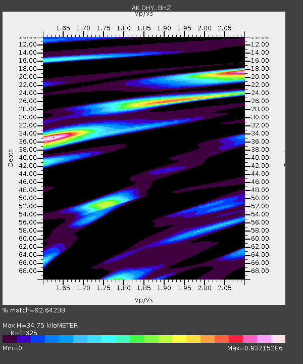
| Estimated Moho Depth: |
34.75 km |
| Estimated Crust Vp/Vs: |
1.62 |
| Assumed Crust Vp: |
6.566 km/s |
| Estimated Crust Vs: |
4.041 km/s |
| Estimated Crust Poisson's Ratio: |
0.20 |
|
| Radial Match: |
92.64238 % |
| Radial Bump: |
400 |
| Transverse Match: |
82.30501 % |
| Transverse Bump: |
400 |
| SOD ConfigId: |
18369291 |
| Insert Time: |
2019-07-08 01:05:58.942 +0000 |
| GWidth: |
2.5 |
| Max Bumps: |
400 |
| Tol: |
0.001 |
|

Signal To Noise
| Channel | StoN | STA | LTA |
| AK:DHY: :BHZ:20190624T01:17:32.967988Z | 36.541615 | 2.1810888E-6 | 5.968781E-8 |
| AK:DHY: :BHN:20190624T01:17:32.967988Z | 7.3708925 | 4.88504E-7 | 6.627474E-8 |
| AK:DHY: :BHE:20190624T01:17:32.967988Z | 14.872244 | 9.511057E-7 | 6.395173E-8 |
| Arrivals |
| Ps | 3.4 SECOND |
| PpPs | 14 SECOND |
| PsPs/PpSs | 17 SECOND |


