You are here: Home > Network List > GS - US Geological Survey Networks Stations List
> Station DEC05 Decatur Surface Seismic Site, Decatur, IL, USA > Earthquake Result Viewer
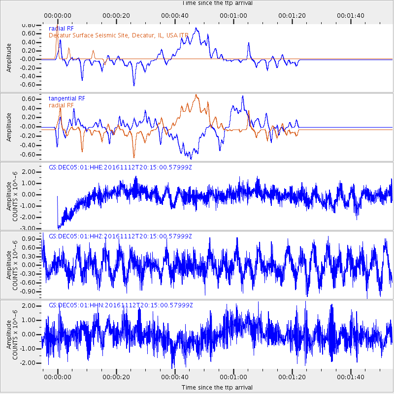
DEC05 Decatur Surface Seismic Site, Decatur, IL, USA - Earthquake Result Viewer
*The percent match for this event was below the threshold and hence no stack was calculated.
| Earthquake location: |
South Of Panama |
| Earthquake latitude/longitude: |
6.1/-82.6 |
| Earthquake time(UTC): |
2016/11/12 (317) 20:08:46 GMT |
| Earthquake Depth: |
10 km |
| Earthquake Magnitude: |
5.6 Mwb |
| Earthquake Catalog/Contributor: |
NEIC PDE/us |
|
| Network: |
GS US Geological Survey Networks |
| Station: |
DEC05 Decatur Surface Seismic Site, Decatur, IL, USA |
| Lat/Lon: |
39.87 N/88.87 W |
| Elevation: |
216 m |
|
| Distance: |
34.1 deg |
| Az: |
351.365 deg |
| Baz: |
168.814 deg |
| Ray Param: |
$rayparam |
*The percent match for this event was below the threshold and hence was not used in the summary stack. |
|
| Radial Match: |
30.811089 % |
| Radial Bump: |
400 |
| Transverse Match: |
26.095797 % |
| Transverse Bump: |
400 |
| SOD ConfigId: |
1858631 |
| Insert Time: |
2016-12-09 05:42:11.748 +0000 |
| GWidth: |
2.5 |
| Max Bumps: |
400 |
| Tol: |
0.001 |
|
Signal To Noise
| Channel | StoN | STA | LTA |
| GS:DEC05:01:HHZ:20161112T20:15:00.57999Z | 0.78622013 | 2.864058E-7 | 3.6428193E-7 |
| GS:DEC05:01:HHN:20161112T20:15:00.57999Z | 1.2682163 | 7.299005E-7 | 5.7553314E-7 |
| GS:DEC05:01:HHE:20161112T20:15:00.57999Z | 0.7869255 | 7.980876E-7 | 1.0141845E-6 |
| Arrivals |
| Ps | |
| PpPs | |
| PsPs/PpSs | |


