You are here: Home > Network List > AV - Alaska Volcano Observatory Stations List
> Station MAPS Pakushin Southeast, Makushin Volcano, Alaska > Earthquake Result Viewer
MAPS Pakushin Southeast, Makushin Volcano, Alaska - Earthquake Result Viewer
| Earthquake location: |
Irian Jaya, Indonesia |
| Earthquake latitude/longitude: |
-2.9/138.5 |
| Earthquake time(UTC): |
2019/06/24 (175) 01:05:28 GMT |
| Earthquake Depth: |
22 km |
| Earthquake Magnitude: |
6.1 Mww |
| Earthquake Catalog/Contributor: |
NEIC PDE/us |
|
| Network: |
AV Alaska Volcano Observatory |
| Station: |
MAPS Pakushin Southeast, Makushin Volcano, Alaska |
| Lat/Lon: |
53.81 N/166.94 W |
| Elevation: |
333 m |
|
| Distance: |
72.3 deg |
| Az: |
30.474 deg |
| Baz: |
238.657 deg |
| Ray Param: |
0.0537055 |
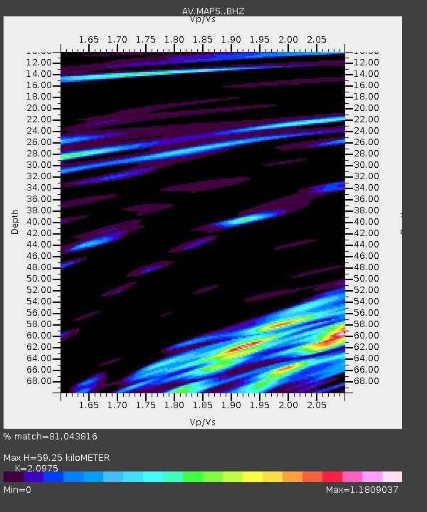
| Estimated Moho Depth: |
59.25 km |
| Estimated Crust Vp/Vs: |
2.10 |
| Assumed Crust Vp: |
3.943 km/s |
| Estimated Crust Vs: |
1.88 km/s |
| Estimated Crust Poisson's Ratio: |
0.35 |
|
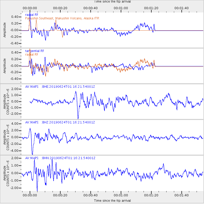
| Radial Match: |
81.043816 % |
| Radial Bump: |
400 |
| Transverse Match: |
77.25695 % |
| Transverse Bump: |
400 |
| SOD ConfigId: |
18369291 |
| Insert Time: |
2019-07-08 01:06:59.789 +0000 |
| GWidth: |
2.5 |
| Max Bumps: |
400 |
| Tol: |
0.001 |
|
Signal To Noise
| Channel | StoN | STA | LTA |
| AV:MAPS: :BHZ:20190624T01:16:21.54001Z | 14.426272 | 2.2389363E-6 | 1.5519853E-7 |
| AV:MAPS: :BHN:20190624T01:16:21.54001Z | 4.978812 | 7.8477905E-7 | 1.5762376E-7 |
| AV:MAPS: :BHE:20190624T01:16:21.54001Z | 5.7703686 | 1.2813467E-6 | 2.2205631E-7 |
| Arrivals |
| Ps | 17 SECOND |
| PpPs | 46 SECOND |
| PsPs/PpSs | 63 SECOND |


