You are here: Home > Network List > TA - USArray Transportable Network (new EarthScope stations) Stations List
> Station A14A Double T Ranch, Babb, MT, USA > Earthquake Result Viewer
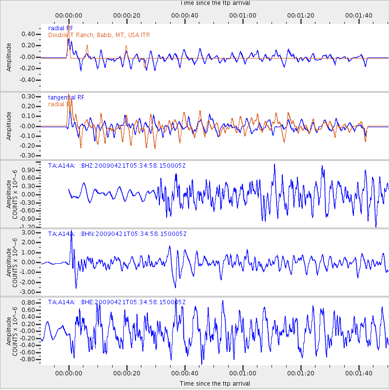
A14A Double T Ranch, Babb, MT, USA - Earthquake Result Viewer
*The percent match for this event was below the threshold and hence no stack was calculated.
| Earthquake location: |
Kuril Islands |
| Earthquake latitude/longitude: |
50.8/155.0 |
| Earthquake time(UTC): |
2009/04/21 (111) 05:26:11 GMT |
| Earthquake Depth: |
152 km |
| Earthquake Magnitude: |
6.0 MB, 6.2 MW, 6.2 MW |
| Earthquake Catalog/Contributor: |
WHDF/NEIC |
|
| Network: |
TA USArray Transportable Network (new EarthScope stations) |
| Station: |
A14A Double T Ranch, Babb, MT, USA |
| Lat/Lon: |
48.97 N/113.42 W |
| Elevation: |
1420 m |
|
| Distance: |
55.2 deg |
| Az: |
53.301 deg |
| Baz: |
309.501 deg |
| Ray Param: |
$rayparam |
*The percent match for this event was below the threshold and hence was not used in the summary stack. |
|
| Radial Match: |
82.35095 % |
| Radial Bump: |
400 |
| Transverse Match: |
72.32405 % |
| Transverse Bump: |
400 |
| SOD ConfigId: |
2658 |
| Insert Time: |
2010-03-07 00:28:13.401 +0000 |
| GWidth: |
2.5 |
| Max Bumps: |
400 |
| Tol: |
0.001 |
|
Signal To Noise
| Channel | StoN | STA | LTA |
| TA:A14A: :BHN:20090421T05:34:58.150005Z | 12.340697 | 1.1983919E-6 | 9.710894E-8 |
| TA:A14A: :BHE:20090421T05:34:58.150005Z | 2.993953 | 3.4299566E-7 | 1.1456281E-7 |
| TA:A14A: :BHZ:20090421T05:34:58.150005Z | 2.1418383 | 3.130299E-7 | 1.461501E-7 |
| Arrivals |
| Ps | |
| PpPs | |
| PsPs/PpSs | |


