You are here: Home > Network List > MM - Myanmar National Seismic Network Stations List
> Station TGI Taung Gyi, Myanmar > Earthquake Result Viewer
TGI Taung Gyi, Myanmar - Earthquake Result Viewer
| Earthquake location: |
Irian Jaya, Indonesia |
| Earthquake latitude/longitude: |
-2.9/138.5 |
| Earthquake time(UTC): |
2019/06/24 (175) 01:05:28 GMT |
| Earthquake Depth: |
22 km |
| Earthquake Magnitude: |
6.1 Mww |
| Earthquake Catalog/Contributor: |
NEIC PDE/us |
|
| Network: |
MM Myanmar National Seismic Network |
| Station: |
TGI Taung Gyi, Myanmar |
| Lat/Lon: |
20.77 N/97.03 E |
| Elevation: |
1458 m |
|
| Distance: |
46.9 deg |
| Az: |
301.981 deg |
| Baz: |
115.137 deg |
| Ray Param: |
0.070300065 |
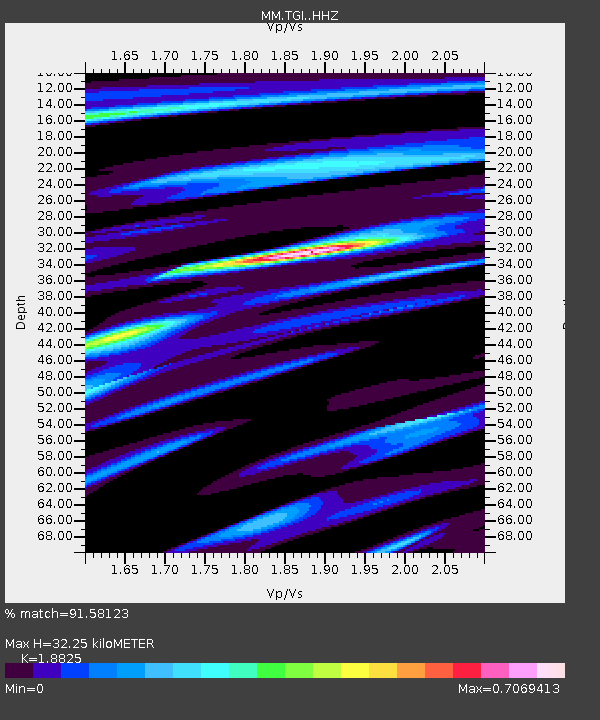
| Estimated Moho Depth: |
32.25 km |
| Estimated Crust Vp/Vs: |
1.88 |
| Assumed Crust Vp: |
6.316 km/s |
| Estimated Crust Vs: |
3.355 km/s |
| Estimated Crust Poisson's Ratio: |
0.30 |
|
| Radial Match: |
91.58123 % |
| Radial Bump: |
203 |
| Transverse Match: |
75.11762 % |
| Transverse Bump: |
369 |
| SOD ConfigId: |
18369291 |
| Insert Time: |
2019-07-08 01:08:35.544 +0000 |
| GWidth: |
2.5 |
| Max Bumps: |
400 |
| Tol: |
0.001 |
|

Signal To Noise
| Channel | StoN | STA | LTA |
| MM:TGI: :HHZ:20190624T01:13:26.79001Z | 39.665604 | 2.0616774E-6 | 5.197645E-8 |
| MM:TGI: :HHN:20190624T01:13:26.79001Z | 10.954596 | 5.1541923E-7 | 4.7050506E-8 |
| MM:TGI: :HHE:20190624T01:13:26.79001Z | 12.885044 | 9.585165E-7 | 7.438984E-8 |
| Arrivals |
| Ps | 4.8 SECOND |
| PpPs | 14 SECOND |
| PsPs/PpSs | 19 SECOND |


