You are here: Home > Network List > TA - USArray Transportable Network (new EarthScope stations) Stations List
> Station B18K Kokolik River, AK, USA > Earthquake Result Viewer
B18K Kokolik River, AK, USA - Earthquake Result Viewer
| Earthquake location: |
Irian Jaya, Indonesia |
| Earthquake latitude/longitude: |
-2.9/138.5 |
| Earthquake time(UTC): |
2019/06/24 (175) 01:05:28 GMT |
| Earthquake Depth: |
22 km |
| Earthquake Magnitude: |
6.1 Mww |
| Earthquake Catalog/Contributor: |
NEIC PDE/us |
|
| Network: |
TA USArray Transportable Network (new EarthScope stations) |
| Station: |
B18K Kokolik River, AK, USA |
| Lat/Lon: |
69.36 N/161.80 W |
| Elevation: |
222 m |
|
| Distance: |
82.4 deg |
| Az: |
17.988 deg |
| Baz: |
240.462 deg |
| Ray Param: |
0.04689084 |
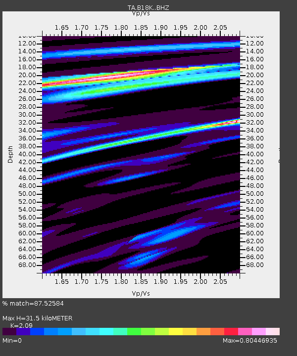
| Estimated Moho Depth: |
31.5 km |
| Estimated Crust Vp/Vs: |
2.09 |
| Assumed Crust Vp: |
5.906 km/s |
| Estimated Crust Vs: |
2.826 km/s |
| Estimated Crust Poisson's Ratio: |
0.35 |
|
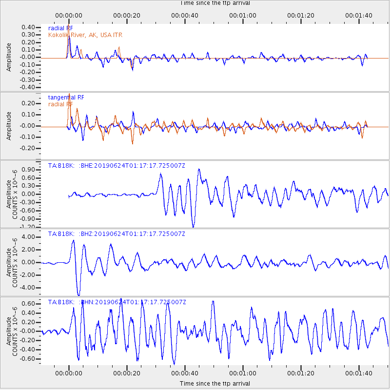
| Radial Match: |
87.52584 % |
| Radial Bump: |
312 |
| Transverse Match: |
82.91403 % |
| Transverse Bump: |
361 |
| SOD ConfigId: |
18369291 |
| Insert Time: |
2019-07-08 01:09:04.271 +0000 |
| GWidth: |
2.5 |
| Max Bumps: |
400 |
| Tol: |
0.001 |
|
Signal To Noise
| Channel | StoN | STA | LTA |
| TA:B18K: :BHZ:20190624T01:17:17.725007Z | 28.176268 | 2.7275996E-6 | 9.680486E-8 |
| TA:B18K: :BHN:20190624T01:17:17.725007Z | 7.3334208 | 3.4790975E-7 | 4.744167E-8 |
| TA:B18K: :BHE:20190624T01:17:17.725007Z | 11.025451 | 4.250304E-7 | 3.8549935E-8 |
| Arrivals |
| Ps | 5.9 SECOND |
| PpPs | 16 SECOND |
| PsPs/PpSs | 22 SECOND |


