You are here: Home > Network List > TA - USArray Transportable Network (new EarthScope stations) Stations List
> Station B22K Teshekpuk Lake, AK, USA > Earthquake Result Viewer
B22K Teshekpuk Lake, AK, USA - Earthquake Result Viewer
| Earthquake location: |
Irian Jaya, Indonesia |
| Earthquake latitude/longitude: |
-2.9/138.5 |
| Earthquake time(UTC): |
2019/06/24 (175) 01:05:28 GMT |
| Earthquake Depth: |
22 km |
| Earthquake Magnitude: |
6.1 Mww |
| Earthquake Catalog/Contributor: |
NEIC PDE/us |
|
| Network: |
TA USArray Transportable Network (new EarthScope stations) |
| Station: |
B22K Teshekpuk Lake, AK, USA |
| Lat/Lon: |
70.34 N/153.42 W |
| Elevation: |
50 m |
|
| Distance: |
85.4 deg |
| Az: |
18.36 deg |
| Baz: |
248.366 deg |
| Ray Param: |
0.044740416 |
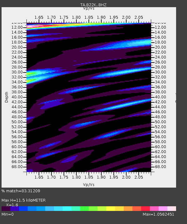
| Estimated Moho Depth: |
11.5 km |
| Estimated Crust Vp/Vs: |
1.60 |
| Assumed Crust Vp: |
5.738 km/s |
| Estimated Crust Vs: |
3.586 km/s |
| Estimated Crust Poisson's Ratio: |
0.18 |
|
| Radial Match: |
83.31209 % |
| Radial Bump: |
400 |
| Transverse Match: |
78.895836 % |
| Transverse Bump: |
335 |
| SOD ConfigId: |
18369291 |
| Insert Time: |
2019-07-08 01:09:07.457 +0000 |
| GWidth: |
2.5 |
| Max Bumps: |
400 |
| Tol: |
0.001 |
|

Signal To Noise
| Channel | StoN | STA | LTA |
| TA:B22K: :BHZ:20190624T01:17:33.17502Z | 30.584223 | 2.2894137E-6 | 7.485603E-8 |
| TA:B22K: :BHN:20190624T01:17:33.17502Z | 2.300489 | 1.7651288E-7 | 7.6728426E-8 |
| TA:B22K: :BHE:20190624T01:17:33.17502Z | 9.196561 | 6.8375834E-7 | 7.434935E-8 |
| Arrivals |
| Ps | 1.2 SECOND |
| PpPs | 5.1 SECOND |
| PsPs/PpSs | 6.3 SECOND |


