You are here: Home > Network List > TA - USArray Transportable Network (new EarthScope stations) Stations List
> Station C16K Lisburne Hills, AK, USA > Earthquake Result Viewer
C16K Lisburne Hills, AK, USA - Earthquake Result Viewer
| Earthquake location: |
Irian Jaya, Indonesia |
| Earthquake latitude/longitude: |
-2.9/138.5 |
| Earthquake time(UTC): |
2019/06/24 (175) 01:05:28 GMT |
| Earthquake Depth: |
22 km |
| Earthquake Magnitude: |
6.1 Mww |
| Earthquake Catalog/Contributor: |
NEIC PDE/us |
|
| Network: |
TA USArray Transportable Network (new EarthScope stations) |
| Station: |
C16K Lisburne Hills, AK, USA |
| Lat/Lon: |
68.27 N/165.34 W |
| Elevation: |
102 m |
|
| Distance: |
80.7 deg |
| Az: |
18.261 deg |
| Baz: |
237.202 deg |
| Ray Param: |
0.048054114 |
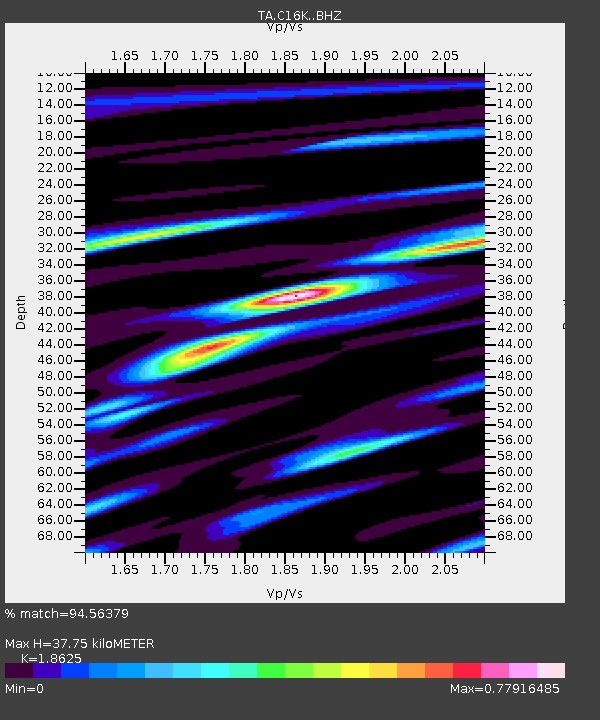
| Estimated Moho Depth: |
37.75 km |
| Estimated Crust Vp/Vs: |
1.86 |
| Assumed Crust Vp: |
5.906 km/s |
| Estimated Crust Vs: |
3.171 km/s |
| Estimated Crust Poisson's Ratio: |
0.30 |
|
| Radial Match: |
94.56379 % |
| Radial Bump: |
390 |
| Transverse Match: |
78.67789 % |
| Transverse Bump: |
400 |
| SOD ConfigId: |
18369291 |
| Insert Time: |
2019-07-08 01:09:08.112 +0000 |
| GWidth: |
2.5 |
| Max Bumps: |
400 |
| Tol: |
0.001 |
|
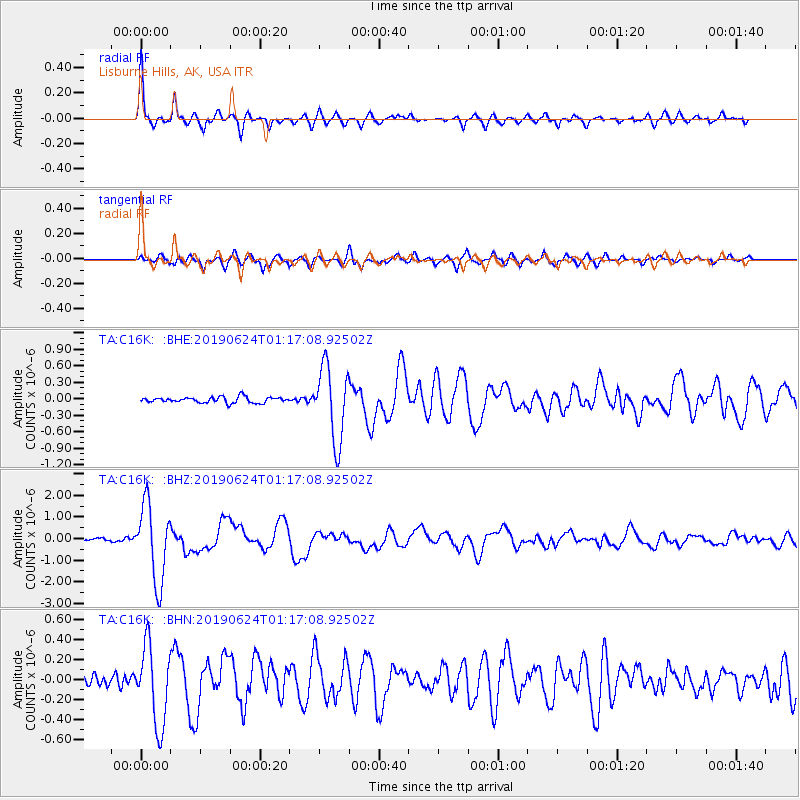
Signal To Noise
| Channel | StoN | STA | LTA |
| TA:C16K: :BHZ:20190624T01:17:08.92502Z | 23.712759 | 1.7729366E-6 | 7.47672E-8 |
| TA:C16K: :BHN:20190624T01:17:08.92502Z | 7.3337803 | 3.9357462E-7 | 5.3665996E-8 |
| TA:C16K: :BHE:20190624T01:17:08.92502Z | 12.771126 | 6.740691E-7 | 5.278071E-8 |
| Arrivals |
| Ps | 5.6 SECOND |
| PpPs | 18 SECOND |
| PsPs/PpSs | 24 SECOND |


