You are here: Home > Network List > TA - USArray Transportable Network (new EarthScope stations) Stations List
> Station D17K Noatak River, AK, USA > Earthquake Result Viewer
D17K Noatak River, AK, USA - Earthquake Result Viewer
| Earthquake location: |
Irian Jaya, Indonesia |
| Earthquake latitude/longitude: |
-2.9/138.5 |
| Earthquake time(UTC): |
2019/06/24 (175) 01:05:28 GMT |
| Earthquake Depth: |
22 km |
| Earthquake Magnitude: |
6.1 Mww |
| Earthquake Catalog/Contributor: |
NEIC PDE/us |
|
| Network: |
TA USArray Transportable Network (new EarthScope stations) |
| Station: |
D17K Noatak River, AK, USA |
| Lat/Lon: |
67.70 N/163.08 W |
| Elevation: |
172 m |
|
| Distance: |
81.2 deg |
| Az: |
19.212 deg |
| Baz: |
239.445 deg |
| Ray Param: |
0.047762875 |
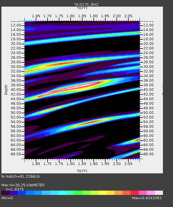
| Estimated Moho Depth: |
38.25 km |
| Estimated Crust Vp/Vs: |
1.84 |
| Assumed Crust Vp: |
6.276 km/s |
| Estimated Crust Vs: |
3.415 km/s |
| Estimated Crust Poisson's Ratio: |
0.29 |
|
| Radial Match: |
91.226616 % |
| Radial Bump: |
273 |
| Transverse Match: |
92.323875 % |
| Transverse Bump: |
374 |
| SOD ConfigId: |
18369291 |
| Insert Time: |
2019-07-08 01:09:12.933 +0000 |
| GWidth: |
2.5 |
| Max Bumps: |
400 |
| Tol: |
0.001 |
|

Signal To Noise
| Channel | StoN | STA | LTA |
| TA:D17K: :BHZ:20190624T01:17:11.17502Z | 26.88892 | 1.6710567E-6 | 6.214667E-8 |
| TA:D17K: :BHN:20190624T01:17:11.17502Z | 11.731686 | 5.118719E-7 | 4.3631573E-8 |
| TA:D17K: :BHE:20190624T01:17:11.17502Z | 9.403409 | 4.955061E-7 | 5.26943E-8 |
| Arrivals |
| Ps | 5.2 SECOND |
| PpPs | 17 SECOND |
| PsPs/PpSs | 22 SECOND |


