You are here: Home > Network List > TA - USArray Transportable Network (new EarthScope stations) Stations List
> Station E20K Nigu River, AK, USA > Earthquake Result Viewer
E20K Nigu River, AK, USA - Earthquake Result Viewer
| Earthquake location: |
Irian Jaya, Indonesia |
| Earthquake latitude/longitude: |
-2.9/138.5 |
| Earthquake time(UTC): |
2019/06/24 (175) 01:05:28 GMT |
| Earthquake Depth: |
22 km |
| Earthquake Magnitude: |
6.1 Mww |
| Earthquake Catalog/Contributor: |
NEIC PDE/us |
|
| Network: |
TA USArray Transportable Network (new EarthScope stations) |
| Station: |
E20K Nigu River, AK, USA |
| Lat/Lon: |
68.26 N/156.19 W |
| Elevation: |
866 m |
|
| Distance: |
83.7 deg |
| Az: |
19.913 deg |
| Baz: |
245.924 deg |
| Ray Param: |
0.045964446 |
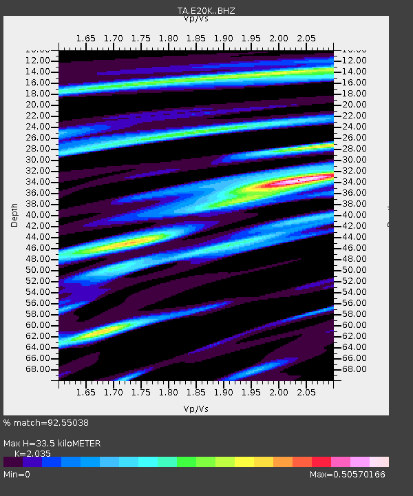
| Estimated Moho Depth: |
33.5 km |
| Estimated Crust Vp/Vs: |
2.04 |
| Assumed Crust Vp: |
6.221 km/s |
| Estimated Crust Vs: |
3.057 km/s |
| Estimated Crust Poisson's Ratio: |
0.34 |
|
| Radial Match: |
92.55038 % |
| Radial Bump: |
351 |
| Transverse Match: |
93.2516 % |
| Transverse Bump: |
360 |
| SOD ConfigId: |
18369291 |
| Insert Time: |
2019-07-08 01:09:19.015 +0000 |
| GWidth: |
2.5 |
| Max Bumps: |
400 |
| Tol: |
0.001 |
|
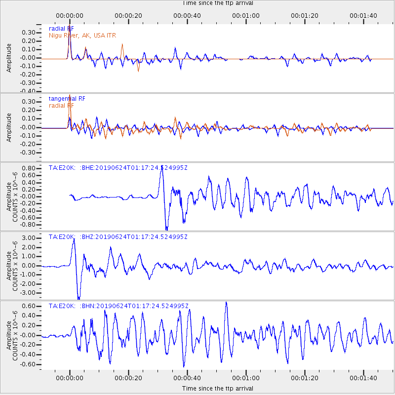
Signal To Noise
| Channel | StoN | STA | LTA |
| TA:E20K: :BHZ:20190624T01:17:24.524995Z | 39.373184 | 1.9496172E-6 | 4.9516366E-8 |
| TA:E20K: :BHN:20190624T01:17:24.524995Z | 6.950383 | 1.6250256E-7 | 2.3380375E-8 |
| TA:E20K: :BHE:20190624T01:17:24.524995Z | 15.305134 | 5.281009E-7 | 3.4504822E-8 |
| Arrivals |
| Ps | 5.7 SECOND |
| PpPs | 16 SECOND |
| PsPs/PpSs | 22 SECOND |


