You are here: Home > Network List > TA - USArray Transportable Network (new EarthScope stations) Stations List
> Station F21K Alatna River, AK, USA > Earthquake Result Viewer
F21K Alatna River, AK, USA - Earthquake Result Viewer

| Earthquake location: |
Irian Jaya, Indonesia |
| Earthquake latitude/longitude: |
-2.9/138.5 |
| Earthquake time(UTC): |
2019/06/24 (175) 01:05:28 GMT |
| Earthquake Depth: |
22 km |
| Earthquake Magnitude: |
6.1 Mww |
| Earthquake Catalog/Contributor: |
NEIC PDE/us |
|
| Network: |
TA USArray Transportable Network (new EarthScope stations) |
| Station: |
F21K Alatna River, AK, USA |
| Lat/Lon: |
67.22 N/153.48 W |
| Elevation: |
597 m |
|
| Distance: |
84.3 deg |
| Az: |
21.278 deg |
| Baz: |
248.569 deg |
| Ray Param: |
0.04558162 |
| Estimated Moho Depth: |
53.25 km |
| Estimated Crust Vp/Vs: |
2.01 |
| Assumed Crust Vp: |
6.455 km/s |
| Estimated Crust Vs: |
3.216 km/s |
| Estimated Crust Poisson's Ratio: |
0.33 |
|
| Radial Match: |
90.37168 % |
| Radial Bump: |
400 |
| Transverse Match: |
84.3262 % |
| Transverse Bump: |
400 |
| SOD ConfigId: |
18369291 |
| Insert Time: |
2019-07-08 01:09:29.407 +0000 |
| GWidth: |
2.5 |
| Max Bumps: |
400 |
| Tol: |
0.001 |
|
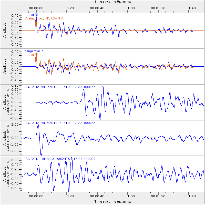
Signal To Noise
| Channel | StoN | STA | LTA |
| TA:F21K: :BHZ:20190624T01:17:27.30002Z | 32.980907 | 1.4380323E-6 | 4.360196E-8 |
| TA:F21K: :BHN:20190624T01:17:27.30002Z | 6.2057047 | 2.2708393E-7 | 3.659277E-8 |
| TA:F21K: :BHE:20190624T01:17:27.30002Z | 11.098309 | 3.798383E-7 | 3.422488E-8 |
| Arrivals |
| Ps | 8.5 SECOND |
| PpPs | 24 SECOND |
| PsPs/PpSs | 33 SECOND |


