You are here: Home > Network List > TA - USArray Transportable Network (new EarthScope stations) Stations List
> Station H18K Honhosa River, AK, USA > Earthquake Result Viewer
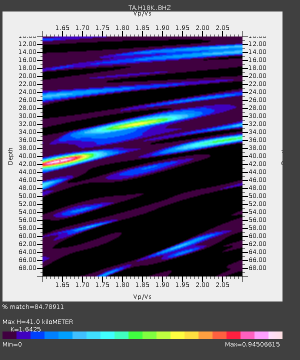
H18K Honhosa River, AK, USA - Earthquake Result Viewer
| Earthquake location: |
Irian Jaya, Indonesia |
| Earthquake latitude/longitude: |
-2.9/138.5 |
| Earthquake time(UTC): |
2019/06/24 (175) 01:05:28 GMT |
| Earthquake Depth: |
22 km |
| Earthquake Magnitude: |
6.1 Mww |
| Earthquake Catalog/Contributor: |
NEIC PDE/us |
|
| Network: |
TA USArray Transportable Network (new EarthScope stations) |
| Station: |
H18K Honhosa River, AK, USA |
| Lat/Lon: |
65.15 N/158.36 W |
| Elevation: |
494 m |
|
| Distance: |
81.6 deg |
| Az: |
22.397 deg |
| Baz: |
244.245 deg |
| Ray Param: |
0.047434412 |
| Estimated Moho Depth: |
41.0 km |
| Estimated Crust Vp/Vs: |
1.64 |
| Assumed Crust Vp: |
6.1 km/s |
| Estimated Crust Vs: |
3.714 km/s |
| Estimated Crust Poisson's Ratio: |
0.21 |
|
| Radial Match: |
84.78911 % |
| Radial Bump: |
400 |
| Transverse Match: |
73.523285 % |
| Transverse Bump: |
400 |
| SOD ConfigId: |
18369291 |
| Insert Time: |
2019-07-08 01:09:42.347 +0000 |
| GWidth: |
2.5 |
| Max Bumps: |
400 |
| Tol: |
0.001 |
|

Signal To Noise
| Channel | StoN | STA | LTA |
| TA:H18K: :BHZ:20190624T01:17:13.649995Z | 20.32691 | 1.308198E-6 | 6.4357934E-8 |
| TA:H18K: :BHN:20190624T01:17:13.649995Z | 4.1929584 | 1.9109429E-7 | 4.5575053E-8 |
| TA:H18K: :BHE:20190624T01:17:13.649995Z | 9.51092 | 4.287161E-7 | 4.50762E-8 |
| Arrivals |
| Ps | 4.4 SECOND |
| PpPs | 17 SECOND |
| PsPs/PpSs | 22 SECOND |


