You are here: Home > Network List > TA - USArray Transportable Network (new EarthScope stations) Stations List
> Station A14A Double T Ranch, Babb, MT, USA > Earthquake Result Viewer
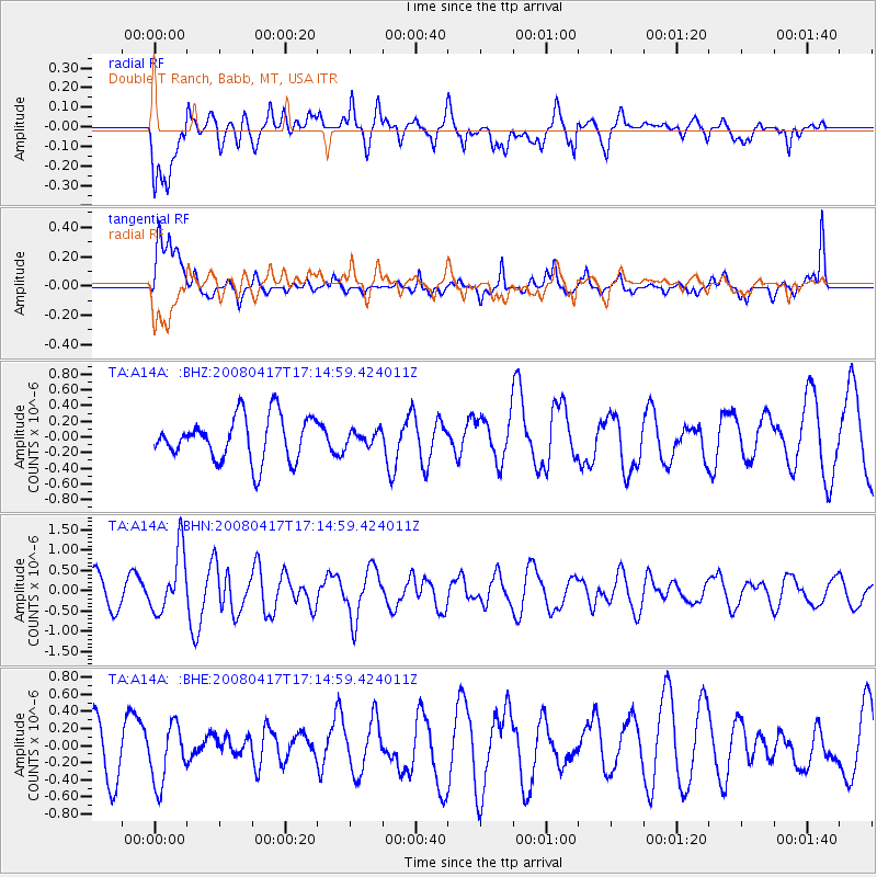
A14A Double T Ranch, Babb, MT, USA - Earthquake Result Viewer
*The percent match for this event was below the threshold and hence no stack was calculated.
| Earthquake location: |
Mariana Islands Region |
| Earthquake latitude/longitude: |
15.9/144.9 |
| Earthquake time(UTC): |
2008/04/17 (108) 17:02:52 GMT |
| Earthquake Depth: |
10 km |
| Earthquake Magnitude: |
5.5 MB, 5.2 MS, 5.5 MW, 5.5 MW |
| Earthquake Catalog/Contributor: |
WHDF/NEIC |
|
| Network: |
TA USArray Transportable Network (new EarthScope stations) |
| Station: |
A14A Double T Ranch, Babb, MT, USA |
| Lat/Lon: |
48.97 N/113.42 W |
| Elevation: |
1420 m |
|
| Distance: |
85.6 deg |
| Az: |
40.324 deg |
| Baz: |
289.085 deg |
| Ray Param: |
$rayparam |
*The percent match for this event was below the threshold and hence was not used in the summary stack. |
|
| Radial Match: |
57.838737 % |
| Radial Bump: |
400 |
| Transverse Match: |
64.29942 % |
| Transverse Bump: |
400 |
| SOD ConfigId: |
2504 |
| Insert Time: |
2010-03-07 00:28:45.010 +0000 |
| GWidth: |
2.5 |
| Max Bumps: |
400 |
| Tol: |
0.001 |
|
Signal To Noise
| Channel | StoN | STA | LTA |
| TA:A14A: :BHN:20080417T17:14:59.424011Z | 2.2152264 | 7.6111434E-7 | 3.4358308E-7 |
| TA:A14A: :BHE:20080417T17:14:59.424011Z | 0.94285655 | 3.4960257E-7 | 3.7079084E-7 |
| TA:A14A: :BHZ:20080417T17:14:59.424011Z | 0.33480102 | 9.3887955E-8 | 2.804291E-7 |
| Arrivals |
| Ps | |
| PpPs | |
| PsPs/PpSs | |


