You are here: Home > Network List > TA - USArray Transportable Network (new EarthScope stations) Stations List
> Station J26L Joseph Creek, AK, USA > Earthquake Result Viewer
J26L Joseph Creek, AK, USA - Earthquake Result Viewer
| Earthquake location: |
Irian Jaya, Indonesia |
| Earthquake latitude/longitude: |
-2.9/138.5 |
| Earthquake time(UTC): |
2019/06/24 (175) 01:05:28 GMT |
| Earthquake Depth: |
22 km |
| Earthquake Magnitude: |
6.1 Mww |
| Earthquake Catalog/Contributor: |
NEIC PDE/us |
|
| Network: |
TA USArray Transportable Network (new EarthScope stations) |
| Station: |
J26L Joseph Creek, AK, USA |
| Lat/Lon: |
64.50 N/143.56 W |
| Elevation: |
1144 m |
|
| Distance: |
87.4 deg |
| Az: |
25.071 deg |
| Baz: |
257.893 deg |
| Ray Param: |
0.043340933 |
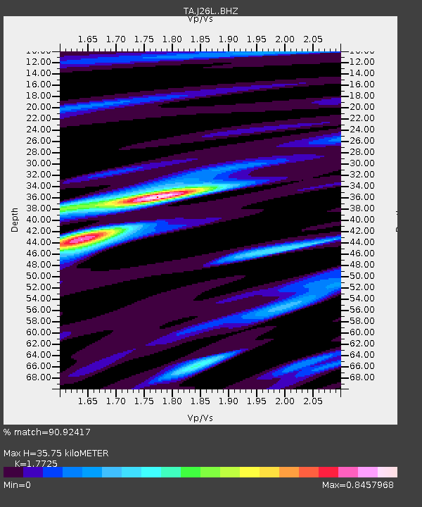
| Estimated Moho Depth: |
35.75 km |
| Estimated Crust Vp/Vs: |
1.77 |
| Assumed Crust Vp: |
6.566 km/s |
| Estimated Crust Vs: |
3.704 km/s |
| Estimated Crust Poisson's Ratio: |
0.27 |
|
| Radial Match: |
90.92417 % |
| Radial Bump: |
400 |
| Transverse Match: |
78.59863 % |
| Transverse Bump: |
400 |
| SOD ConfigId: |
18369291 |
| Insert Time: |
2019-07-08 01:09:56.218 +0000 |
| GWidth: |
2.5 |
| Max Bumps: |
400 |
| Tol: |
0.001 |
|

Signal To Noise
| Channel | StoN | STA | LTA |
| TA:J26L: :BHZ:20190624T01:17:42.67502Z | 33.115208 | 1.7596086E-6 | 5.3135967E-8 |
| TA:J26L: :BHN:20190624T01:17:42.67502Z | 3.164453 | 1.10076776E-7 | 3.4785405E-8 |
| TA:J26L: :BHE:20190624T01:17:42.67502Z | 17.99241 | 6.8682664E-7 | 3.8173134E-8 |
| Arrivals |
| Ps | 4.3 SECOND |
| PpPs | 15 SECOND |
| PsPs/PpSs | 19 SECOND |


