You are here: Home > Network List > TA - USArray Transportable Network (new EarthScope stations) Stations List
> Station M13K Dall Lake, AK, USA > Earthquake Result Viewer
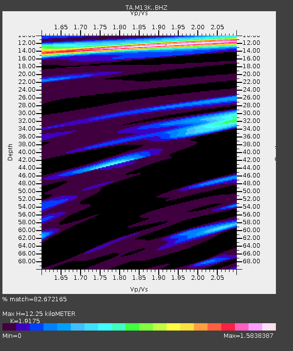
M13K Dall Lake, AK, USA - Earthquake Result Viewer
| Earthquake location: |
Irian Jaya, Indonesia |
| Earthquake latitude/longitude: |
-2.9/138.5 |
| Earthquake time(UTC): |
2019/06/24 (175) 01:05:28 GMT |
| Earthquake Depth: |
22 km |
| Earthquake Magnitude: |
6.1 Mww |
| Earthquake Catalog/Contributor: |
NEIC PDE/us |
|
| Network: |
TA USArray Transportable Network (new EarthScope stations) |
| Station: |
M13K Dall Lake, AK, USA |
| Lat/Lon: |
60.41 N/163.35 W |
| Elevation: |
9.0 m |
|
| Distance: |
77.4 deg |
| Az: |
25.594 deg |
| Baz: |
240.395 deg |
| Ray Param: |
0.050336987 |
| Estimated Moho Depth: |
12.25 km |
| Estimated Crust Vp/Vs: |
1.92 |
| Assumed Crust Vp: |
6.1 km/s |
| Estimated Crust Vs: |
3.181 km/s |
| Estimated Crust Poisson's Ratio: |
0.31 |
|
| Radial Match: |
82.672165 % |
| Radial Bump: |
400 |
| Transverse Match: |
65.51213 % |
| Transverse Bump: |
371 |
| SOD ConfigId: |
18369291 |
| Insert Time: |
2019-07-08 01:10:07.077 +0000 |
| GWidth: |
2.5 |
| Max Bumps: |
400 |
| Tol: |
0.001 |
|

Signal To Noise
| Channel | StoN | STA | LTA |
| TA:M13K: :BHZ:20190624T01:16:50.649995Z | 17.088448 | 3.1854306E-6 | 1.8640843E-7 |
| TA:M13K: :BHN:20190624T01:16:50.649995Z | 2.92196 | 6.3150634E-7 | 2.1612422E-7 |
| TA:M13K: :BHE:20190624T01:16:50.649995Z | 2.216401 | 6.21502E-7 | 2.8041043E-7 |
| Arrivals |
| Ps | 1.9 SECOND |
| PpPs | 5.7 SECOND |
| PsPs/PpSs | 7.6 SECOND |


